2009-03-17 39 -86

| Tue 17 Mar 2009 in 39,-86: 39.1726518, -86.4165445 geohashing.info google osm bing/os kml crox |
Participants
Erik, Kira, and Duncan.
Plans
The location was within 10 miles of our house (and within 50 feet of a road), we were looking for things to do outside, and it was spring break, so it was natural that we would give this one a shot. Besides, we had to take Duncan to the vet that day, and that brought us within 4 miles.
Expedition
Finding the general area by car was pretty easy, and the spot was very close to the road (opposite a cornfield), but it still took us some time to reach it. If things had lined up nicely, it would have been a 50-foot trudge up the side of a hill through dead brush and live brambles, but that would also have involved navigating a small fence that was old but still barbed. I'm not entirely certain why the fence is there. At some point in time, it was about 50 feet long, but some parts of it had fallen over and been overrun by foliage. It didn't actually surround anything and there were no signs, so we felt it would be okay to just walk around it.
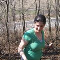
The weather in the past week had been unusually warm, so I (Erik) was wearing shorts, which made me a lot more cautious about navigating the thorny bushes. If only they had been as dry as the rest of the plants, we could have stomped them underfoot and snapped them off, making life a lot easier. But they were sadly still alive and whip-back-at-the-person-behind-you flexible. Duncan was not helpful, and often tried to drag Kira towards the fence.
But after fifteen minutes or so of trudging through this mildly annoying terrain, we made it. Since our last trip, I picked up a cheap GPS device on eBay, so now I have proof!
Afterwards, we went to Bruster's for ice cream.
Photos
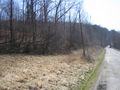
The view from the road

Erik, on the spot
Kira, navigating thorny branches
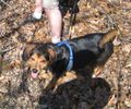
Duncan, on the spot
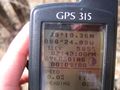
Proof!


