2009-04-10 49 -118
| Fri 10 Apr 2009 in Grand Forks, British Columbia: 49.8624990, -118.9597201 geohashing.info google osm bing/os kml crox |
Location
North of Big White.
Participants
Planning
Despite my troubles with snow-covered forest service roads on my last expedition, I had a couple reasons to believe this one would be different. First, I was close to last week's Kelowna expedition, which had clear roads and barely any snow. Second, I was under the impression that Okanagan Falls Forest Service Road was well-traveled and maintained. The road would bring me to less than 2km from the coordinates.
Expedition
The drive out to Big White Road was fun. It's a popular place, but I had never been there. CBC Radio was interviewing David Suzuki, recently elected the most popular living Canadian, and receiver of our government's highest civilian honour. While I forget his exact words, he didn't hesitate to call our Prime Minister an idiot.
It didn't take long for Okanagan Falls FSR to become packed with mud and increasing levels of snow. It appeared even the snowmobilers had given up on accessing the area. I was approximately 7.5km away, and it wasn't a particularly nice area to attempt a hike that I knew I wouldn't finish. I turned around.
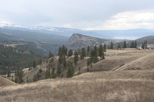
The weather was also ugly, but I wanted at least one photo, so I stopped near the iconic Layer Cake Hill. I found that the ditches and roadsides were dumping grounds for just about anything. Enough ugliness for one day.
Lessons Learned
- Geography means little for snow levels. Pay more attention to altitudes.
- Areas neighboring the east side of Kelowna really do have serious garbage problems.
