2009-04-11 36 -84
| Sat 11 Apr 2009 in Williamsburg, KY: 36.5143502, -84.6418935 geohashing.info google osm bing/os kml crox |
Contents
About
This hash falls on public land within the Big South Fork National River and Recreation Area (locally abbreviated BISO). The hash point appears to be just below the rim of the gorge, at the top of a steep talus-and-cliff slope.
Planning
.jpg)
The hard way
The obvious approach route is to travel along the river until directly below the hash, and then attempt to climb up to the hash point near the top of the gorge, probably involving a series of steep brushy slopes interspersed with cliffs. Success seems unlikely.
The easy way
It might be better to approach from the top of the plateau, and rappel down to the hash point from the rim. It might even be possible to reach the hash while on rappel. (Air Geohash Achievement?) Then the rope could be ascended with mechanical ascenders and the approach hike reversed. The view at the rim should be spectacular for photography, especially near sunset.
Leaving the car just inside the park on Station Camp Road would provide a 3.2 km hike over (apparently) gently rolling, forested terrain to reach the the rappel point at the rim of the gorge. Hiking near the edge of the park on a due south bearing for the first two kilometers should minimize the elevation changes.
The weather forecast calls for partly cloudy skies and a high temperature of about 15 C (59 degrees F), with only a 10% chance of rain.
Expeditions
Packing (for) the worst
The proposed expedition was a bit more equipment-intensive than usual, so a bigger pack was required. In addition to the usual GPS, compass and camera, the pack had to accommodate a 50-m climbing rope, two 10-m lengths of nylon webbing, seat harness, rappelling gear, mechanical ascenders, two headlamps, space blanket, first aid kit, cell phone, food and water. A sufficiently large pack, found at the back of the closet, turned out to be very old. The waterproof lining was delaminating, and one of the straps broke when the pack was lifted fully loaded. Creative retying made the pack functional again, if slightly lopsided.
Initial optimism
Tossing the pack into the back of the car, I began the drive to the hash. I normally don't drive to a hash unless it's a detour during a trip that I would otherwise be making anyway, but this hash was sufficiently interesting that an exception was warranted. The partly cloudy skies soon gave way to a wet fog. "At least," I thought, "it's not raining." Right on cue, the rain began.
By the time I reached BISO and set off on foot, the weather had reverted to light fog with occasional bursts of sunlight. Being behind schedule, it was encouraging to see that the terrain was gently rolling and the forest was largely free of underbrush, just as I had imagined. I would clearly be able to make up some time on the hike and arrive at the gorge with plenty of time for unhurried photography, before rappelling down to meet my fellow geohashers. Idly wondering what games they might have brought, I realized that I had forgotten to bring a game myself. Mentally cursing this oversight, I awakened from my daydreams to confront a wall of dripping rhododendron and laurel.
Reality sets in
After a mere 700 meters, the forest had suddenly changed from "open" to nearly impenetrable. There was no apparent way around the thicket, so I plunged in, fighting and climbing and crawling. Within minutes I was completely soaked and my glasses were fogged and splashed to the point of uselessness. After floundering up over a short ridge, I stopped to wipe off my glasses with the cleanest patch of fabric I could find (which turned out to be, um, under my other clothing). Looking blurrily across the ravine at the way forward, I was surprised to see a line of cliffs rising from the jungle of rhododendron. Their height varied from five to ten meters, interrupted by wet gullies that looked climbable. Apparently I was farther to the west than planned, where the terrain was steeper. It seemed strange though, to have cliffs on the far side of the ravine but not on my side. I struggled downslope through the wet brush for another five meters, and looked down....
The cliffs of despair
... straight down, about 15 meters. Despite having a rope, I couldn't simply rappel this. The rope had to be reserved for the rappel at the gorge, not left here. I struggled along the top of the cliff for a few minutes before finding an easy downclimb of 2 meters. From the bottom, I could see that these cliffs were all pretty spectacular overhangs with plant-free zones in the sheltered area along the base.
An eternity of wet thrashing carried me across the rhododendron-filled ravine to the dripping cliffs on the other side, which were similarly overhung. Traversing the base of the cliff led me to a low spot where a muddy mantle provided access to the bottom of a steep brushy gully. Slowly slogging up the ridge, the brush gradually changed from rhododendron to mountain laurel, which was a little easier to crash through. Past the top of the ridge, however, the difficulty of the mountain laurel was increased by a dense maze of downed pine trees, recent victims of the southern pine beetle.
The rotting, slippery logs seemed to come to rest on each other at an average height of about a meter above the ground: too low to duck under wearing a pack, but too high to step over. Some of the logs were solid enough to hold my weight but were generally too rain-slicked to balance on. The only way forward was to crawl/clamber from log to log over the laurel, getting snagged repeatedly on the dead branches. Sometimes I proceeded 20 meters without touching the ground. The fact that I was heading downslope again made the struggle less strenuous, but I wasn't looking forward to the return trip. Oh yeah, the trip. Just how far I come? Time to drop the pack, futilely attempt to clean the glasses, and turn on the GPS... 2.28 km remaining.
Wait, what?
The last 320 meters had taken about an hour to traverse. Well, maybe all of the obstacles were behind me now. I put on my blurry glasses to look forward across to the other side of the ravine, and saw... more cliffs. Well, of course. {sigh} But there appeared to be a route around them. It seemed strange though, to have cliffs on the far side of the ravine but not on my side. Say....
Once again I was resting only a few meters from the top of the cliff on my side of the ravine. Moving laterally along the top of the cliffs to find an easy downclimb would be a very time-consuming struggle. So I doubled a piece of webbing around a small tree and arm-rappelled about five meters to the base, pulling the webbing down after me. A few more minutes of thrashing through rhododendron brought me to the stream at the bottom of the ravine. Well, not quite at the bottom. I was looking down another 10-meter cliff at the stream. Then there was another 10-meter cliff rising on the other side of the stream and above that, the upper line of cliffs that I had noticed minutes earlier from my higher vantage point.
Too many obstacles, too little time. It was time to take out the GPS again to record the "closest approach" coordinates (2.20 km to go), and turn for home. After a couple of quick pictures, I heaved the pack onto my shoulder, and the second strap broke off. {sigh} More creative re-tying ensued.
The return trip
Slow. Strenuous. Wet. Re-read a couple of paragraphs above.
Parasites
One tick. I'm guessing that a photo is not desired.
Photos
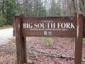
Welcome to BISO.
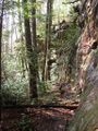
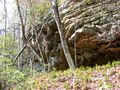
Encountered these cliffs from above.
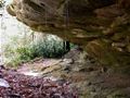
Encountered these cliffs from below.
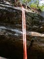
Pull-down arm rappel.
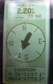
Halted by Cliffs of Despair at 2.20 km from hash.
Encountered new and different cliffs on return trip.
.jpg)
.jpg)
.jpg)
.jpg)
.jpg)
.jpg)