2009-04-17 -33 149
| Fri 17 Apr 2009 in Bathurst: -33.5152987, 149.6611671 geohashing.info google osm bing/os kml crox |
Contents
Location
The hash falls on a ridge between O'Connell and Lagoon. 800 metres from the side of a road that doesn't exist...
Attendees
Report
Looked like an easy ride according to the map. Just had to ride down the highway a bit, past my old school, and along the road for about 10km until a signposted right turn. Well, the turn isn't signposted, the road isn't level, and the highway is, well, a highway. Once you get past the traffic and you get to the top of the hill, it's fairly easy.
And I realise something is wrong when I find a left hand turn for Wests Lane, which I'm not meant to reach. Back up the hill a bit and the turn I was meant to take has had a small quarry or something built on it. Well, I've come this far, I can't stop now. So I skirt around it and continue on (passing over the scariest bridge I've seen in a while). Up the road a bit and I see a house off the side a bit, so I go up just in case the road is part of their property but no one was home. Oh well, let's keep going anyway.
Further uphill, and I am roughly 800 metres away from the hash. It's a good thing I'm on a mountain bike because the road leading me this far was dirt, the road ahead was sand, and the road leading to the hash isn't there. After a small cross country excursion I finally reached the point! My first human powered success! I wasn't fond of the idea of going back along the highway so I had a quick look on the map and the road I was following apparently continued for another few kilometres until it rejoined a sealed road that would lead me to Lagoon. The only problem with that plan was I didn't know the quality of this road, and it had been degrading for a while.
Well, I was right to be suspicious. The road went from sand to a set of tire tracks, to a depressed area of grass. I spent the next half hour riding in the lowest possible gear (with a short downhill section, fun but bumpy). I had my hopes dashed halfway through the ride when what I thought was a road turned out to be a creek. I did eventually find the road. Two locked gates stood between me and freedom though. I can't believe I got this far and only now get stopped by locked gates. So I lift my bike over (I do love bicycles, nice and light) and start riding up another fucking hill.
Once I reached the peak I got treated to a view of Chifley Dam and a loooooong downhill section all the way to Lagoon. From there the return journey was pretty much the same as my previous trips in that area. Well, with one small change. Near the end I decided I hadn't ridden up enough hills so I detoured along an unsealed road (really I was trying to avoid the traffic). It looked so short on the map but it still gets very disheartening when you are 4km from home and you ride 500m away from your destination. Eventually a tired Ephphatha made it home, vowing never to take that detour again.
Total time elapsed: 3:17
Total distance traveled: 44.2km
Photos

Tiny hut in the middle of a field opposite my old school.

Creepy bridge.
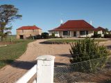
Empty house with a cobweb covered door.

800 metres and closing.
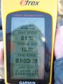
The GPS says the hash is 30cm towards the rear of the bike, right where I'm sitting. Therefore I'm directly on it!
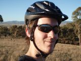
Goofy grin, dry lips, and I couldn't even be bothered taking my helmet off for you lot.

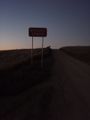
The road well traveled.

The locked gate and my bike.

The view of Chifley Dam.
Yeah, thanks for the advice.


Achievements
Ephphatha earned the Graticule Unlocked Achievement
|
Ephphatha earned the Land geohash achievement
|