2009-04-28 49 -122
| Tue 28 Apr 2009 in Surrey: 49.2375398, -122.8303430 geohashing.info google osm bing/os kml crox |
Contents
Location
Today's hashpoint in the Surrey graticule appears to be in somebody's kitchen (or at least, just inside the house on the back by what appears to be a deck) in Coquitlam. The backyard appears to be fenced.
Planning
What planning? There was no coordination or planning for this beyond what is on the talk page. Rhonda created an expedition page noting the urban hashpoint, Sue mentioned her nearness and availability, Robyn posted what time she planned to be there, and didn't stay around to notice the others attempting to get there in time.
Participants
Expedition
Robyn
This geohash is only 22 km from my home. My original idea was to try it en route to a possibly accessible location in Chilliwack, which is one of only two graticules that I need in order to minesweep Bellingham. The point in Chilliwack is almost exactly 100 km by road from the Surrey point, and I would have to ride at least half that back again in order to reach transit for an easier way home. To reduce the total amount I would have to ride in the day, I decided to take transit part of the way to Coquitlam.

So T-Rex, bike and I hopped on the SkyTrain. We weren't sure whether Braid or Lougheed Centre would be a better stop, but when the train got to Braid that was less than four kilometres from the geohash, so seemed close enough. I got my bearings and followed Brunette Avenue across the train tracks and Highway One through that awkward little bit of semi-civilization made up of liquor stores, country & western bars and computer repair shops, at the point where the Lougheed crosses Brunette. I stayed on Brunette through the community of Maillardville, the Frenchest part of the whole province of Columbie-Britanique, and waited for Brunette to turn right. I was to stay straight ahead on Dawes Hill Road.
Fans of my adventures, native Coquitlamians (what do you call yourselves?), and anyone with a gram of sense in their head know what is coming when Robyn plans a trip up Dawes Hill Road. But I quite innocently failed to parse the Hill part of it until I saw it. There really wasn't much doubt. It looks quite innocent in the photo. It must use cloaking technology. It was nasty. I had to stand up and lean forward to keep the front wheel from coming off the ground. Sue later laughed at me for not knowing any better than to ride up that road. But ride I did. All the way. It was too steep to walk in bike shoes.
The geohash showed up a left and two rights later. I didn't see Sue at first, so I looked for a back way, didn't find one, returned to the front and there she was, replete with the news that still others were expected. Waiting for them was the perfect excuse not to ride another 160 km today. Chilliwack can wait.
After everyone had arrived, been photographed, and eaten some of my chocolate chip cookies, I went up to the door of the house to see if there was someone inside who had somehow managed not to notice people congregating in their driveway for the last half hour. No one answered the bell, so I tucked the Google Maps printout under the edge of the doormat where it would be visible. It was a hybrid view showing the teardrop marker on their house, and also showing the peeron URL, should they want to investigate. The others suggested that the occupants might find that a little creepy, so I didn't compound the matter by putting any chalk marks on the driveway.
I also feel compelled to point out that I once studied Halkomelem, the first language spoken in this place, just long enough to know that "Coquitlam" means "stinking of fish slime". Just so you know. And the 7 in the orthography, a different orthography than I learned, but I looked it up, represents a glottal stop after a vowel, so like the sound between the two syllables in English "oh-oh".
Rhonda
Robyn said she'd be at the hash point at a time that was insufficient for me to get there, even if I knew the route, which I didn't. That planned scouting of the Iron Workers Memorial Bridge bike routes? Hasn't happened yet. The bike route planner I found a while back insisted that I ride all the way up Burnaby Mountain to SFU, or at least that's what it looked like to me, so I ignored it and entered the co-ordinates into my GPS, noting only that it had told me to get on the left side of the bridge instead of the right side.
I managed to leave home about a half hour after Robyn had posted her ETA, and followed the cycle route to the left side of the bridge as instructed. Sure enough, the signs posted for bicycles didn't say "one way" the way they do on the Lions Gate Bridge, but instead informed me that I had to yield to oncoming cyclists. Clearly this is a two-lane bicycle route.
I was quickly disabused of that notion when I got on the bridge.
Fortunately there was no oncoming traffic, because I was unable to figure out how two bicycles could pass each other: possibly with one stopped and leaning against the railing and the other walking carefully past. I was having difficulty navigating the narrow path as a single bicycle, with the gusts of wind coming over the bridge and from the vehicles passing me.
I didn't take a picture, because I was too terrified. I'll return another day and take a picture on foot, I think.
Once I survived the bridge, there was a bike trail leading straight up the side of a hill. A very steep hill. So steep in fact that the side of the hill that the highway was cut out of is held up by a rather tall retaining wall, and the hill climbs up from there. Eventually I found my way to the top of that hill, losing the bicycle route in the process, and started zig-zagging across Burnaby. I had a few goals in my seemingly random turns: keep going toward the geohash, don't climb Burnaby Mountain, and don't lose too much of that hard-won altitude because I'd just have to climb it again.
I had to backtrack only a couple of times, once because the road turned away and once because a golf course was in the way. Eventually I found a bike route that went in the right direction, and followed that.
About half an hour after Robyn had said she'd be at the hash point, I was finally less than 3km away, so I stopped to phone SueB, who I knew from elsewhere. She advised me on the better road to follow, since the bike route I was on ended only a block farther, and let me know that I would be the fourth person to show up at the hash point that day.
I rode on the recommended road until my GPS indicated the point was directly to the side, then coasted down a long hill, checking frequently to make sure I didn't pass the turn I wanted. I didn't want to climb back up the hill. I turned in one street too soon, on the optimistically named "Paradise Road", but that wasn't it; the very next road turned out to be the one I wanted. Sure enough, there were three people standing in a driveway, waving at me.
SueB
My day started innocently enough until Xore randomly mentioned that today's Geo-hash was in someone's kitchen in Coquitlam. I decided I'd better check to make sure it wasn't mine. It wasn't... but the hashpoint was less than a kilometre away (776m as the crow flies - thanks Robyn), there was no excuse not to go.
Armed with my cell phone, camera and location I walked up the street to meet up with Robyn. From the map, it looked like I could get closer to the hashpoint from the back of the house which conveniently bordered Dawes Hill Park. Alas, not only was the yard fenced, but it was atop a 15 foot retaining wall surrounded by prickly blackberry bushes. Hmmm, maybe wearing shorts wasn't the best idea for this venture.
I walked along the groomed path to head up the hill when I spied a shortcut and decided to take it. Short, steep & scratchy I met up with Robyn at the front of the house. While we waited for Rhonda who was enroute an email came through on my blackberry that Yangman was also on his way.
After the obligatory pictures, we trekked back to my place and spent the afternoon lounging on my back lawn. What a great intro to geo hashing.
yangman
Having stayed up late the night before helping a couple friends move out of their apartment, I did not manage to wake up until it was almost 11 am. Sleepily making my way through the previous day's emails, new RSS feeds, and webcomics after a quick breakfast, I finally decided to check the day's hash location at 11:17. I was about 7.5km away, but only 13 minutes to Robyn's ETA.
Being a Coquitlam resident of more than a decade, I knew my way around by bike, but only the section between Como Lake Ave. and Austin Rd. I had no clue how cycling friendly it was south of Austin Rd, especially as far east as the hash location. To my disappointment, City of Coquitlam's website was having connectivity issues in the morning, and I was not able to pull up a cycling map for the area—it was the only one of which I did not already have a PDF or printed map. It turned out to be not much of an issue as there is only one route going south to the hash point that didn't involve a long detour.
Time being of the essence, lacking a GPS or any sort of portable direction-finding device, I hastily scribbled down the final two turns I needed to make into my note pad, grabbed a handful of granola bars, haphazardly stuffed my pannier bag, brushed my teeth, changed, pumped another 40PSI each into the tires of a bike I haven't ridden in months, and was out the door by 11:35.
The trip was uneventful, as most trips through Coquitlam's cycling-friendly areas are. Robyn and Sue were waiting when I eventually arrived, and I introduced myself as being from The Internets.
First Geo Hashing attempt: success (well, close enough).
Abduction
Once we had exhausted the entertainment possibilities of an inaccessible geohash in someone's house or back deck, we suggested to Sue that she earn an Abduction geohash ribbon by taking the people she had just met in a driveway back to her place. (Is that a reverse abduction?) She agreed, and quickly calculated the best way to do that with bicycles.
She served us iced tea, the unsweetened kind, made with green tea and we lounged around on the freshly mowed (thanks Scott) back lawn where we were visited by a woodpecker and a robin and some small lawn bugs, as well as by Sue's brother Scott. He seemed completely unsurprised that we were from the Internet. That's apparently where Sue gets most of the people she brings home.
Home

After leaving Sue's, we decided to to make our way back west via Brunett Ave. As any Coquitlam native will attest to, this is a terrible route to travel even by car during rush hour, and gets increasingly worse as one heads west towards the on-ramp to Highway #1; doing so on bikes was not only unpleasant but ridiculously dangerous. After a few blocks, just as we were approaching the dangerous area, it was decided that the best thing to do was to climb north into central Coquitlam to less congested suburban streets.
Yang led Robyn and Rhonda to the bike trail that was supposed to lead around the south side of Burnaby Mountain. At first we suspected he was angling for an abduction ribbon of his own, but it turns out that the riding is much better on the bike route even if you do need to go about ten blocks up another big hill to get there.
Thanks to Yang's guidance, Rhonda and Robyn only got a tiny bit lost on the way home. (Is it lost if you know which body of water you're looking at, and where you have to be in relation to it, but are not immediately sure how to get there without going through an industrial site?) We also found a bit of the Trans-Canada Trail and Robyn found a bike route she'd never heard of.
It was a thoroughly fine way to waste a day.
Photos
The first two batches of slightly more photos than we need to show how much fun we had in a stranger's driveway.
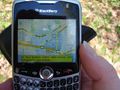
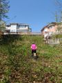
The Blackberry can't find the hashpoint.
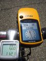
The etrex can, but it's not where we are.
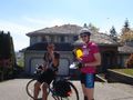
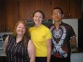
Robyn and Yangman in front of the house.
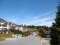
A beautiful day
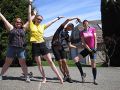
Our xkcd sign
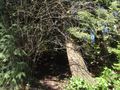
Sue found a secret trail in the park.
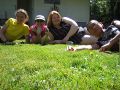
Walking through thorns couldn't get us close enough at the back.
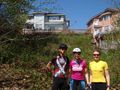
We still smile.
Sue abducted us.
Robyn couldn't find a game in her bag.
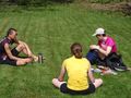
So we basked in the sun
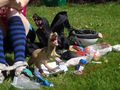
Even T-Rex
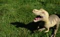
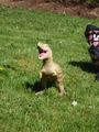
RAWR!
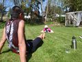
And Sue photographed Robyn while she ...
...photographed everyone.


