2009-05-07 48 8
| Thu 7 May 2009 in Pforzheim, Germany: 48.6390393, 8.7938193 geohashing.info google osm bing/os kml crox |
Location
In a forest near Deckenpfronn
Expedition by Ekorren
This was a hard one to decide, as it would have also been possible to go to some remote graticule today. But in the end I decided to take a rather near trip that would be possible all by bike, although it would be quite boring. Boring, because the hash was in the very same forest as 2009-03-22 48 8. After visiting the hash, I would want to proceed to Stuttgart this time. Counting the whole thing as a trip to Stuttgart, it would be a huge detour, though.
I packed most things I would need, got on my bike and started through the Ammer valley. As the trip would be quite long, and feature a good number of slopes, I went for what I suspected to be the fastest way this time - through Herrenberg, Kuppingen, and then on the same track I had taken back from the other hash. A significant difference was there, anyway: When I was there last time, it was still kind of end-winter, now it was middle of spring. Nothing really remarkable happened on the way.
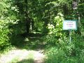
At the last larger forest track intersection before the hash I took a closer look at the signs and found that they call this particular spot Dreiländereck (Three countries corner) and the track Grenzweg (Border way). Apart from a new time district border, I wasn't aware of any, even historical, borders here. And neither was a historical atlas I consulted after getting home - seems there never have been any significant borders for several centuries. The name of that spot still needs to be resolved, then...
Now I got near to the hash, which again was somewhere in the forest. The good news: Both the topographic map and OSM showed a track passing very near to the hash. The bad news: I hadn't packed either of them for this place, so I had no idea where the actual track would part from the main track I was on. I could just guess. Guessed wrong on the first try and turned around, guessed wrong as well on the second try but did not turn around. Rather, left the bike at the point closest to the hash and stumbled through the underwoods for the missing 100m.
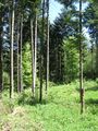
The point itself wasn't thrilling at all, just another forest spot. Left a marker, left the place, got back to the bike.
I had planned to revisit 2009-03-22 48 8, and the track I was on (although being in very bad shape) seemed to go more or less into the right direction, so I continued instead of turning around. The track got worse, didn't turn into the direction I needed, reached the forest margin and vanished. After some cross-meadow part, I found another track, anyway. Which seemed to go more or less into the right direction. Then made some turns and didn't at all anymore. Also, it went downhill. But turning around at that point wasn't an option at all, so I lost a significant amount of elevation metres until I found another track to climb up into the hills again. That one was where I found that tunnel in the photos, and it brought me to a secondary road into the village of Deckenpfronn.
Now having half-circled the retro point, I gave up on the revisiting plans, and instead went on my way for Stuttgart. Another few hours of cycling, but I got there in time. And when people there asked with disbelief whether I really just had come all the way from Tübingen by bike, I couldn't help but answer no, just now I come from Deckenpfronn. Which is even further. And I had gone there from Tübingen just before that.
Gallery
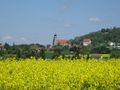
Herrenberg
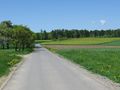
Way into the forest
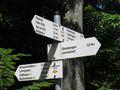
Three countries corner? Border way?
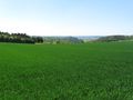
Black Forest view wasn't as impressing as it sounded
Track to hash is closed for riders (on horses, that is).
The hash
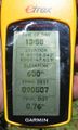
Coordinates reached
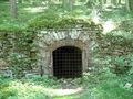
A tunnel of unknown purpose, built 1864.
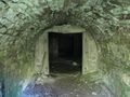
View inside. Two "doors" were visible, behind that it got too dark
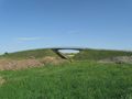
A bridge crossing nothing

I was actually faster on the bike trail than those people on the motorway.


