2009-05-10 57 11

| Sun 10 May 2009 in 57,11: 57.9003955, 11.8551485 geohashing.info google osm bing/os kml crox |
Participants
Expedition
We hadn't really planned the way to todays geohashing point so we just gathered what we needed for the trip, loaded our bikes, met up and took off in a what we supposed was the right direction. After a while we realized that we had chosen a really windy day, (6 - 10 m/s), and the last part when our legs hurt the most we were heading straight towards the wind. After hours of pedaling and a short nachochip-energy-refill-stop we reached our destination. That meant "Picnic time!". On our way back we ended up on a different path which turned out to be much better for biking. Therefore the trip only took about 2 hours compared to the 3 hours we used getting to the hash. To end our Sunday bike mission we decided to visit a friend of ours that since yesterday lives almost on our track home.
Achievements
Jonatan and Gabriel earned the Graticule Unlocked Achievement
|
Jonatan and Gabriel earned the Land geohash achievement
|
Jonatan and Gabriel earned the Bicycle geohash achievement
|
Jonatan and Gabriel earned the Picnic achievement
|
Photos

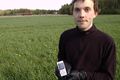
Gabriel
Jonatan
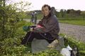
Picnic


