2009-05-13 49 11
| Wed 13 May 2009 in Nürnberg: 49.2956643, 11.4288156 geohashing.info google osm bing/os kml crox |
Location
Today's location is on a track between fields near Pölling (which is part of Neumarkt in der Oberpfalz).
Country: Germany; state: Bayern (Bavaria, EU:DE:BY); administrative region: Oberpfalz; district: Neumarkt in der Oberpfalz
Weather: clouded
Expedition
Danatar
I had planned to go to Aschaffenburg later today. The cheapest ticket for that is the Bayernticket, which allows unlimited connections in Bavaria on the same day. To get the maximum benefit for the same price, I decided to use it in the morning for a geohashing expedition. When I was on the train and halfway to Nuremberg, I received a call that my appointment had been rescheduled to Thursday, but by then it was already too late to turn back.
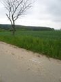
I took the train to Nuremberg, where I had to wait 55 minutes for the connecting train to Pölling. In Pölling, I walked along quiet streets, with nobody to be seen (probably because of lunchtime). The route to the hashpoint was easy, but when I arrived I found out that Google's satellite view is out-of-date, as usual: The road, which is visible on the road map, doesn't exist in the satellite picture. For a few moments I walked back and forth, turning the map in every direction and counting the trees, then I decided on a piece of track for the marker.
On the way back, I met a small cat at the next farm. It didn't look healthy at all and seemed to have breathing problems, but it liked me and followed me for a while. The train ride did not bring anything mentionable.
This is a new graticule for me, that means my Regiohash progress for Bavaria is now 5/20.
Distance by train: 134.8*2 = 269.6 km; distance on foot: 2.2 + 2.2 = 4.4 km
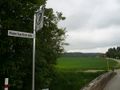
Google says it's called Kesselweg, but they're lying.

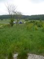
Coordinates reached
Newly-built road north of the hashpoint

Im on ur legz, giving u teh swine fluz


