2009-05-16 48 8
| Sat 16 May 2009 in Pforzheim, Germany: 48.3770048, 8.7785416 geohashing.info google osm bing/os kml crox |
Contents
[hide]Location
On a meadow at Haigerloch, near the incorporated village of Weildorf.
Expedition by Ekorren
As usual, I had planned out an interesting route, researched a number of geocaches along the way, and was sure I would get on my way in good time to be there at 16:00. As usual, it was much later than planned when I really got on my way, so geocaches and most other detours would have to be be skipped.
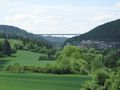
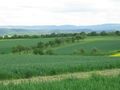
I started from home by bike and went on the Neckartal trail up the valley via Rottenburg to Bieringen. From here I had the choice to take either a route through the Eyach valley or over the hills. The second one was a bit shorter, and possibly also faster, but the first one was more calculable in duration, and since time was already a bit low, I chose the valley route. Continued on the Neckar valley trail to Sulzau, and from there to Eyach station (see here for some more details on that station) I took an alternative route which was possibly a bit slower (although shorter) and yet missing in OSM. Actually, I don't really understand why they continue to send all bike tourists on the main road for several kilometres, claiming that there is no possibility to even build a bike trail - instead of just upgrading this agricultural track from "bad gravel and mud" to a decent tarnac surface. It would be shorter and feature a number of additional nice views. The only downside is a small hill it passes, with about 50 unnecessary elevation metres. It would be entirely possible to get around that one as well, but that would mean to cross a golf site. And the rich people in the local golf club are quite sure that buying the government is included in the price of a club membership and get through with it.
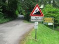
At Eyach station I turned into the Eyach valley, which I followed until Bad Imnau. Until here, I had taken basically the same route as on May 1st, only this time I went by bike and not by train. Now, I had to leave the valley, whether I wanted or not. There weren't many ways up there, and the small road from here to Bittelbronn looked like a good idea on the map... until I met the slope. Crazy 18% were announced at the lower end. I immediately gave up to cover any of this riding and pushed the bike up to the top.
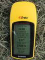
Time seemed to be sufficient for one more small mapping detour, so I went for the missing hamlet of Henstetten, but then time seemed no more enough so I turned a few metres before actually reaching it. Well, better that than nothing. Speeded up, crossed Bittelbronn, and found that I was really low on time if I wanted to make it to the hash at the official time. Three minutes before four, the GPS pointed in a 90° angle into the field, with 200 metres to go. Might it be better to go around the field and approach from the other side? No time for experiments. After all, I seemed to be lucky: This field was not actually growing any crop. It was a meadow with a few trees, and freshly cut grass waiting to convert into hay. I can step on that without bad conscience. Parked the bike, and quickly walked out into the wet meadow. Surrounded by crop fields, the hashpoint itself was in the far corner of that meadow, and when I reached it, the clock still showed 16:00. Ok, a few minutes late would still have counted, probably, but making it there at the exact time with only a few seconds to spare, is better style, isn't it?
I found that I really should have approached from the other side, and took that track back. Found a barbecue place, a totally uninteresting memorial, a good view to the far Castle Hohenzollern (once again) and more trees, went back to the bike and for the town centre of Haigerloch.
Haigerloch is probably best known for the Atomkeller (nuclear cellar). During WW II, while the americans were developing the atomic bomb, the germans did some experiments with nuclear fission as well - just here, in a cave in the middle of the historic town of Haigerloch. What is still denied by some historicans, is that they didn't even seriously try to develop an atomic bomb. They tried on a small reactor for a nuclear power plant. And luckily, they didn't even halfway succeed on that, their reactor never went critical. The cave is a museum now, attracting busloads of tourists. When I visited it a few years ago, I found it not very interesting. It had very obviously been sponsored by a nuclear power lobby, and was very pre-czernobyl.
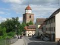
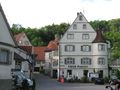
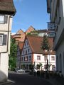
Apart from that, Haigerloch is always worth a visit, though. There is a medieval city centre, nicely placed in and above a deeply cut narrow valley and a large castle on the opposite side. I was surprised to find the tower in the upper part of the town open for public, which it had never been during any of my previous visits. Same for the 19th century jewish cemetery, which is uncommon in that it is located in town (those were usually placed far away from settlements), and also well-preserved. I skipped the castle this time, as it's badly accessible by bike - you need to either carry the bike upstairs for a few hundred steps or do a detour of several kilometres.
A few minutes before 18:00, I left Haigerloch and went for the mountain route I had turned down on the way to the hash. Even found the time to do a little bit of geocaching this time (but did not find the more interesting one of the caches), and reached home with the very last ray of daylight.
Gallery
Along the way
Along the Neckar valley
This wasn't actually a gentle slope
Coordinates reached in time
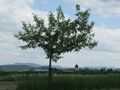
The hash tree
View from hash
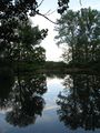
A lake along the way home
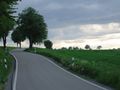
Rural road in the evening


Impressions from Haigerloch
Römerturm
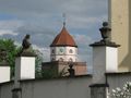
Römerturm
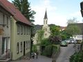
Some church in the upper town
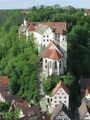
Castle
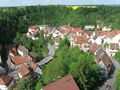
Another view from the Römerturm
Somewhere in the lower town
near Market Square
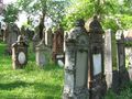
Jewish cemetery


