2009-05-24 -37 145
| Sun 24 May 2009 in -37,145: -37.7976355, 145.3838622 geohashing.info google osm bing/os kml crox |
Contents
[hide]The Place
-37.797636°, 145.383862°. Near the town of Erica, just to the north of the Dandenongs. In bushland but private property a few hundred metres from the nearest road.
Who is going
Felix Dance
I decided to go for this one at ten minutes to one on Sunday afternoon after spending the morning sleeping in, reading a book and bumming around. I checked the train timetable to Lilydale, the nearest rail-head, and found the next train was due to leave Southern Cross Station at a quarter past one - only 25 minutes away! I readied my bike in a hurry and packed my backpack full of everything I thought I might need - food, wet weather gear, GPS, and two pairs of shoes (one for cycling and one for walking). I made it to the station with one minute to spare, but suddenly realised what I'd forgotten: the actual coordinates of the hash point! (As well as a map!)
On the train out to Lilydale I messaged a friend to get the coordinates, but resigned to the fact that I'd have to attempt the geohash without a map.
At Lilydale I entered the newly-messaged coordinates into my GPS, held the device in my hand on the handlebar and followed the arrow pointed towards the point - it was just over 5kms away so not a big ride.
Following directions based on only on two data (direction and distance) is an interesting art. Since I was unfamiliar with the area and it was fairly hilly and thus windy, I found I had to make a lot of decisions based on where I thought the roads after a junction were likely to go - getting in the mind of the road builders back in the day. A lot of the time I'd come to a roundabout and see two roads eventually curving towards my destination, but clearly not meeting up. Which one should I choose? Well the uphill one is more likely to head around the back of the Dandenongs, where I'm sort of heading, whereas the downhill one would probably bend back around towards the city and my route home. So I'd go the uphill way.
After not too much riding along roads largely uphill and through bushy surroundings, including passing the Lilydale to Warburton Rail Trail which I've frequented, I got to the closest point on the road to the geohash - 500m or so. Here I locked up my road bike (not good on the gravel) and tried to make my way towards the point into the bush.
Unfortunately, it looked like a large Christian camp which was occupied at the time, and seemed to take up a lot of the region the geohash point could have been in. At this I walked down the road, away from the hash point, to see if there was a way around, eventually stumbling upon a dirt road underneath a power line that seemed to head in the right direction. the GPS told me I was 800m from the point here.
After walking along the road for a few hundred metres, avoiding an inquisitive and suspicious dog, I came to the end - another boundary of the camp. Luckily, there was what looked like public bushland to the side and a few rough paths leading down into the valley and somewhat towards the point.
Descending into the gloom of the valley (it was already an overcast day) I discovered this geohashing expedition also involved a creek crossing and carefully negotiated the rocks to avoid getting my socks wet.
Climbing up the embankment on the other side (and ignoring the signs telling me the fate of trespassers on this private land - the camp), I came upon a flying fox and followed that towards the point, getting closer to the activities of the camp. Soon I had to ascend further where I encountered a kangaroo (helping to mask my footsteps from good hearing campers).
Near the top of the ridge on the other side of the creek (which I'd got to despite being a fairly circuitous route, probably due to cloud and tree cover affecting the GPS), I came to a clearing where a water pipe descended the hill. Saying G'day to a trail bike rider I worked my way down and back into the bush towards the hash point. Pretty soon the distance had reduced from about 300m to 50m, and it wasn't with too much bush bashing that I reached the exact location of the geohash.
The point itself looked like it sat right on top of an abandoned aqueduct, covered in young trees and dry bark. I didn't hang around too long as the point was in full view of the Christian camp and I could hear that the occupants were involved in some sort of outdoor activity around the corner. Not taking any photos due to not having a camera I quickly cut back to the creek around the camp (taking fewer precautions because my objective had already been achieved). It didn't take me long to get back to my bike on the road; I changed back to cycling shoes and headed off. it took me two and a half hours between deciding to go geohashing and reaching the point.
Rather than going straight back to the station I decided to spend the rest of the afternoon (it was almost 4pm) continuing the ride. I passed around the Silvan Reservoir (very scenic) to the town of Monbulk where I had a pie and a doughnut. I then climbed up the back of Mount Dandenong to Olinda and then the observatory as the light faded. It was a pretty amazing sight from the top - 640m elevation or so - as I could see all of Melbourne lit up in the last gasp of dusk. I stayed there for nearly an hour taking in the views and watching the lights diffusely illuminate the cloud bottoms replacing the glow of sunset.
The rapid descent down the other side of Mount Dandenong towards Montrose was quite a ride. It was pitch dark, with the road and low hanging trees visible only by my flashing front light, punctuated occasionally by the blinding headlights of oncoming or overtaking cars. Since I couldn't see the road surface at all I thought a lot about the role of faith in one's life, clearly influenced by the Christian camp - although it was faith in the state of Victoria's roads rather than some sort of creator.
Travelling along Canterbury Road and then Whitehorse Road I got home to Port Melbourne at about 9pm after stopping off briefly at a friend's house in Mont Albert North to pick up SPD, rather than road bike, peddles for the bike I was riding - the ulterior motive for bringing two pairs of shoes.
Note: I achieved the adjoining Geohash point the very next day! This (barely) qualifies me for the Consecutive Geohash Achievement. Read about my exploits at 2009-05-25 -37 144.
Photos
None Taken - I need a camera. However, have a look at my route here.
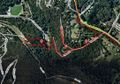
This is an image taken from Gmaps Pedometer of the location.
