2009-06-04 57 12

| Thu 4 Jun 2009 in 57,12: 57.7008689, 12.0839342 geohashing.info google osm bing/os kml crox |
Participants
Expedition
The hash point for today was so close to the city, we had actually no excuse for not getting it. The Danish Metrological Institute had announced some millimeters of rain between five and eight pm, so we decided to wait until it had finnished raining. At eight a'clock, there hadn't still been any rain, so we decided to leave anyway, Of course the rain started when we were on our way on the bikes, but we only got some light rain, so it was pretty ok anyway.
When the road ended we decided to take a smaller path into the wood, which was marked as a mountainbike road. It was indeed very bumpy and steep sometimes, and we actually ended up at a point we could have reached only using a few hundred meters of road. At that point, however we realized bringing the bikes any longer wasn't really an option, so we left them and started walking instead.
The terrain was sometimes quite challenging - four times we had to climb really steep cliffs (and then climb down again later on our way back) - but eventually we made it to the hash point, where Gabriel took the possibilty of giving his dad some phone-based computer service. On our way home it started to get dark, so when trying the last of the four steeps down, we really had to use our imagination in order to find a way, but eventually we arrived home safe and almost unharmed. (Jonatan had an appointment with a pointed stick during one of the climbs, but no wounds were inflicted except from that one.)
Tracklog
Achievements
Jonatan and Gabriel earned the Graticule Unlocked Achievement
|
Jonatan and Gabriel earned the Land geohash achievement
|
Jonatan and Gabriel earned the Bicycle geohash achievement
|
Jonatan and Gabriel achieved level 1 of the Minesweeper Geohash achievement
|
Photos

Gabriel

Jonatan
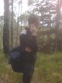
Gabriel trying to fix some computer issues while being in the middle of the forest.


