2009-06-11 49 9
| Thu 11 Jun 2009 in Würzburg: 49.6257228, 9.9413830 geohashing.info google osm bing/os kml crox |
Location
Today's location is in a sugar beet field near Herchsheim, south of Würzburg.
Country: Germany; state: Bayern (Bavaria, EU:DE:BY); administrative region: Unterfranken; district: Würzburg rural district
Weather (15:15): partly sunny, partly clouded, very windy, sometimes light rain, 16°C
Expedition
thepiguy and Danatar
The weather had been not very good in the morning, with strong wind, but in the early afternoon thepiguy and Danatar set out anyway. They arrived at exactly the same time at their meeting point near the Main and continued directly towards the hashpoint. They left Würzburg at Heidingsfeld and followed a little-traveled road all the way uphill to Fuchsstadt.
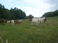
Later, after Giebelstadt, they stood at an intersection in the fields for a while while Danatar figured out on which track according to the map they were and whether to go east or west. thepiguy offered to pull out his GPS, but Danatar just shook his head and took out his compass, reminding thepiguy that not everyone needed technology to find their way around. Finally they Danatar found the correct one and soon passed Herchsheim. Near the hashpoint, they left their bikes and stepped between the sugar beet plants until they reached the hashpoint. Thepiguy had some nibs and they took pictures. Next to that field some cows were standing and watching and on the way back to the bike the geohashers scared a rabbit away, then they turned back towards home.
On their way back they tried another route, which was going uphill in the beginning (and thus very taxing), but from Geroldshausen on they could race downhill until they were back at Würzburg.
Total distance cycled by Danatar: 24.5 + 25.5 = 50 km, 230m uphill
Total distance cycled by thepiguy:45 km (tracklog)
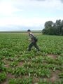
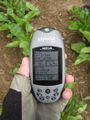
thepiguy is doing the GPS dance.
But it was worth it!
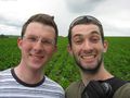
Danatar and thepiguy at the hash.
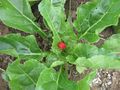
Ahhh! Murray plants!

Eine Kuh (macht MUH)
Viele Kühe (machen Mühe)


