2009-06-20 32 -111
| Sat 20 Jun 2009 in Casa Grande: 32.1625773, -111.7251129 geohashing.info google osm bing/os kml crox |
Participants
Expeditions
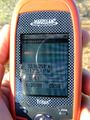
I found out RoadRunner was feeling better, so I dropped off a thirsty, tired dog and met up with a thirsty (I did have to bring the soda), freshly showered adventurer and we were off towards Kitt Peak Observatory. Geohash location actually landed on the Tohono O'odam Reservation. RoadRunner was leery about being able to get there because she was once pulled over on a paved tribal road and told she was trespassing. Needless to say, we were very vigilant about looking for trespass or restriction signs and saw NONE. 10 miles on the paved road, with strange looks from the cows, and 3/4 of a mile on a nice jeep trail got us to within 25 feet of the location.
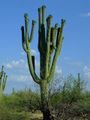
Ironic part is that we had been discussion saguaro cactus a few days earlier and how the buds on the arms never seemed to grow into arms off the first set of arms. So here we are at the geohash location and there are dozens of saguaros with arms on arms. I just had to use that as the defining picture of the location.
Second multihash in two weeks. :) We were rushed to do this second point and both of us forgot to bring the wine. Guess we'll have to make up for it at another time.
Casa Grande, Arizona
Casa Grande, Arizona

