2009-06-21 51 -0
| Sun 21 Jun 2009 in 51,-0: 51.4907867, -0.0213773 geohashing.info google osm bing/os kml crox |
Location
Around number 100 Spindrift Avenue on the Isle of Dogs. Here's a Streetview link looking up the street towards the Hashpoint.
Hashpoint appears to be on the edge of the road and relatively accessible.
Participants
Norsemark planning to visit later in the day (Fathers Day commitments pending).
Plans
Norsemark
Never been onto the Isle of Dogs before and should be able to do most of the journey on public transport, the remainder on foot. It's only quarter of a mile from Mudchute on the Docklands Light Railway and that actual street is served by the D3 and D8 bus routes. Public Transport Achievement ahoy!
Expedition
Background
Since this point was posted on Friday I'd planned to head down - an opportunity to see a bit of that part of London that I'd not previously been in a rush to and a good chance of nailing my first success.
Just as I set off I checked the Geohashing app on my G1 for the point-to-point distance and noticed that it wasn't returning a location. Given as I'd previewed it and knew the approx location (road name and 3 decimal places of the hashpoint) I headed off and figured I'd work out what was wrong on the way and it'd all be roses. The idea was to walk to the station, take a train to London and then the tube and DLR to Mudchute station from which the hashpoint was only a tiny half-mile distance.
Route
Having set off around 3:20pm I got the train to Kings Cross, Northern Line down to Bank and the DLR out to Mudchute without a hitch and everything running smoothly. Got out at Mudchute and rechecked the G1 app - still no joy. Strange. The GPS was still logged my route okay but not showing any map to view and my regular Maps program also failed to return any images. Darn.
Having come to rely upon my phone as a failsafe for getting about I didn't have any maps or directions printed off and so ploughed on based upon the approximate direction I recalled from the web the day before. Except that I hadn't really etched it to memory as well as I'd recalled and ended up on something of a wander around the southern tip of the Isle until I was able to find a local map on a bus stop which helped me to recall Spindrift Road and, more importantly, to find it.
Desperate to defy technology, I resorted to switching the phone off and on again. Sometimes it just works. This time it didn't and I was no better off. In fact, I was worse off, because I had to restart the GPS tracking app, and hence my route map upload is cut into two pieces.
Here was the trouble, though. I'd only recalled the hashpoint to three decimal places (51.491, -0.021) and knew that whilst I could work out where I was, standing on the hashpoint was going to be a tougher assignment because I couldn't nail it down sufficiently. Aarrgh! At least, I thought, I know that the point is on the walled edge of the pathway on the westmost side of the road. So I followed that line precisely until I could be sure I was past the point. And then doubled round and repeated it, just for good measure.
The GPS phone app (mytracks) was still tracking my path, though, but the guide claims that it's only accurate to 20 feet and hence the crazy dance suggested by the google my maps upload (link to follow shortly). I believe that I made the hashpoint, but am perhaps shy of proof. Need to find a way or device to sort my locations more accurately. I suspect I'm in line for the "Blinded By Science" consolation prize...
At this point I was a little cheesed off but still in a positive mood because I had something else occupying my mind. The day before it had struck me how low the fraction of latitude was and checked out the opportunity for a multihash - only a few miles (and the River Thames) stood between us. In spite of my technological incapacity, I still wanted to check it out. And that, I did. With a twist. But that's another hash and another story, so for details, go here.
Tracklog
Because I had to switch the track off and on, this is in two parts.
Part one is here and part two is here, both hosted on Google Maps
Bear in mind that the gaps between points are tunnels - on the train down and also going through the underground tube system.
Achievements
Norsemark earned the Public transport geohash achievement
|
Photos
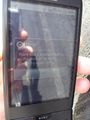
Mobile Internet Fail
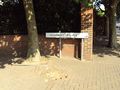
Spindrift Avenue - found!
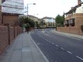
Looking towards Hashpoint
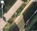
Broken GPS-age


