2009-06-22 36 -114
| Mon 22 Jun 2009 in Mesquite: 36.6261184, -114.4662374 geohashing.info google osm bing/os kml crox |
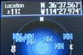
Location
This hashpoint in 36,-114 fell about 300 feet from a two track outside of Logandale, NV in the fertile farm and ranch lands of Moapa Valley, NV. Google Maps showed two tracks that appeared to come off a public dirt road, and head back behind private property.
Participants
- weltfunk - drove up from LV
Expedition
I got out of work late, so it was a race against time to get out that far before the sun went down.
Driving down NV169 into the valley was very odd - there were lots of crops and cows, and the smell of freshly cut grass was in the air. Arriving at the two tracks via public roads was straightforward, although the road transitioned to gravel for the last half mile or so.
The two track that looked public was really quasi-part of a house's driveway that went through a wire fence onto public land behind. Given the number of stables and cow pens and the lack of lights on anywhere, it looked like an agriculture only part of town. I popped down the drive and got onto the two track with my bike, which turned out to be an anchor when the path turned to deep sand. It looked like beautiful beach sand - the Muddy River probably flowed through here at some point. I roughly followed the GPS and the mental map I had made of the satellite view from path to path, . When the waypoint was tangent to the road I set into the scrub in the fading light, anxious to get back to the road before I had none left. The snakes were sleeping, but wildlife tracks were everywhere.
I ended up circling a bush to get my GPS to finally read the exact hashpoint coordinates. I took a couple photos before heading back to the two track, where I was overtaken by youngsters on dirtbikes and quads. How strange it must be to grow up with a wholesome rural lifestyle under the shadow of Sin City.
As I was emerging from the desert, flashlight in hand, I heard talking and was greeted by a flashlight from across the street. The man said nothing, but I went straight over to explain what I was doing. As it turns out, he and his neigbor were both officers with the LVMPD. As is typical in such a rural area, I was pegged as an outsider - I wouldn't be surprised if they had run my plates! He and his wife were both friendly and had heard of geocaching, so we had a good laugh and swapped stories for a bit before I thanked them and headed home. Along the dirt road I was further greeted by a slow-moving police cruiser driving in the opposite direction, but that was all.
The drive back into Vegas is always pretty, since you see the dazzling lights from higher elevations. I was able to see the light from the Luxor shooting up from behind a mountain while I was still 25 miles away! I took some photos outside of town and stopped by the Welcome to Fabulous Las Vegas sign on the south strip, since there aren't many tourists around late on a Monday night.
All in all, a great first geohash!
Gallery
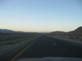
It's pretty desolate out here, but scenic
Sun setting...take photo now!

A beautiful sunset
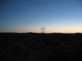
...also with singing power poles (that sound like growling!)
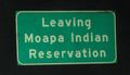
Leaving the Res - it counts as an international border, right??
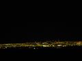
Coming home


Achievements
weltfunk earned the Graticule Unlocked Achievement
|
weltfunk earned the Police Geohash Achievement
|
weltfunk earned the Land geohash achievement
|