2009-07-08 -38 145
| Wed 8 Jul 2009 in -38,145: -38.1267020, 145.3639574 geohashing.info google osm bing/os kml crox |
Contents
[hide]The Place
-38.126703°, 145.363957°. To the south east of Cranbourne in Melbourne's south east.
Who went
Felix Dance
I'd just bought a new pair of cycling shoes when I discovered the location for this hash point just outside cranbourne. This was interesting because it was in the unreached-by-me graticule of -38 145, and was near the NW corner rather than on French Island or somewhere awkward like that. "Great", I though, "A chance to use my new shoes Geohashing tonight". So, without first measuring the distance on Google Maps I set off.
It was already dark when I left home on my shiny road bike in my shiny shoes. I headed down the bay - the scenic route - and watched the moon rise over the suburbs and the container ships embark at Swanston Warf.
Stopping briefly for a Big M and some Tim Tams in Carrum, I headed off to Seaford, where I did my traditional walk along the pier to watch the city lights thing. There were fishermen there using luminescent lures.
After getting lost a bit in Seaford, I was on the road to Cranbourne, where I stopped at Hungry Jacks for a bite. Once I'd passed south of Cranbourne all the streets became increasingly narrow, poorly lit, and less frequented. I ended up on a road that I really couldn't figure if it was sealed or not. By this time a planet had risen brightly in front of me which I took to be Jupiter.
At about 9:30 I turned onto the unsealed road the geohash was supposedly on, only to find that Google Maps had lied and it was not on the road itself but actually 80m off the road towards a very bright point light source that illuminated the fog in the fields for 100s of metres, casting 3-D shadows from the trees.
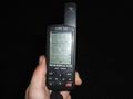
This light source turned out to be the club rooms of a horse racing track and the geohash point turned out to be right in the centre. Despite there clearly being a person occupying the club rooms I ventured out onto the track with my camera and GPS (there were no fences stopping me so I felt this was okay according to Australian property law).
Pretty soon the ground got muddy and wet and I'd already turned my shiny new bike shoes into a blob of sopping horse manure, with my socks already well underwater. As soon as I had stood at the exact location of the geohash I noticed that I was not alone for two reasons: there were several horses eyeing me off suspiciously nearby, and that guy from the clubrooms had suddenly jumped into his car and was speeding towards me.
The light source was doused and I hurried back through the ankle deep water and mud to my bike through the dark. I struggled to find the way out but figured it out just as the car remotely opened the gates and started driving through to where my bike was. I was just putting my reflective jacket back on (I'd taken it off to avoid detection from the point source of light) when the driver stopped next to me and wound down the window.
"You or-right?" He asked.
"Hi, ah yeah, fine thanks". And that was that, he was off.
When he'd gone I took a few hasty photos (I didn't venture back into the mud) and headed off myself, arriving with plenty of time at the Cranbourne Railway Station to take the train home, which time I employed by reading a book and trying not the think of my 6:45am start the next morning (don't work in construction).
Time of geohash start: 18:30.
Time of geohash: 21:45
Time of completion: 23:45
Total distance ridden: 75kms.
Here is the Google Maps route I took.
Photos

My bike near the geohash location.
80m from geohash - I did get there by couldn't take a photo.
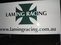
The sign for the race track.
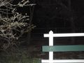
The hash point is just beyond the limit of the flash.


