2009-07-14 49 -122
| Tue 14 Jul 2009 in 49,-122: 49.3504257, -122.8322685 geohashing.info google osm bing/os kml crox |
Contents
Location
In the Siskin Lake/Robin Lake area, east of Buntzen Lake on top of a mountain. There are established hiking trails there. See hiking trails map in photos section.
Participants
Plans
Meet after work and drive to Buntzen Lake picnic area. Hike ~4km on a trail (note: switchbacks - may be longer, will be steep), find hash point, hike down.
Sunset is at 9:13PM. We're bringing headlamps and jackets (and emergency gear) in case we're returning in the dark. Weather forecast calls for clearing skies through the day.
Expedition
"I'm not sure we're going the right way, but look at the view!"
Assembling the Party
Robyn rode the usual collection of transit vehicles (bus, train and boat) across the city and across the Burrard Inlet to a bus loop a few blocks from where Rhonda lives. The schedules connected better than planned, leaving Robyn time to read her book while being accosted by someone who claimed to be from Australia. He lacked an Australian accent, but managed to be barely intelligible anyway. He wanted to know how much for T-Rex. When Robyn explained that T-Rex is Not For Sale, he asked about the book she was reading, then asked Robyn why she wouldn't sell him cigarettes. Eventually he realized that "because I don't smoke" meant that Robyn didn't have any cigarettes, and he went away.
Rhonda arrived in the hashmobile and Robyn got in and talked too much while incompetently providing directions to SFU based on Rhonda's Google Maps printout. "Okay, turn left onto East Hastings, then turn right onto Hastings." Huh? Hastings turned right so we assumed we were done that stage and waited for the street we were on to turn into Burnaby Mountain Parkway. Only it didn't. It turned into the Barnett Highway shortly after we went through the large intersection of East Hastings and Hastings, three lanes over from where we needed to be to turn right. We turned around a few kilometres down Barnett Highway, with the assistance of a pedestrian crossing light and the entrance to a velodrome, this time turning left on Hastings, left on Gaglardi Way and finding ourselves on the SFU campus. The next page of the directions said to turn right on East Road and right again on Sunnydale, so after briefly thinking we were entering a parkade, we drove under one of the campus buildings, past New Caprica (parts of Battlestar Galactica were filmed in front of the futuristic architecture of this campus) and reached a T-Intersection. The choices were University Drive East and West, so we took the former, it being closest to "East Road." We found and collected Xore, and continued towards the trailhead.

This time we got on the Barnett Highway on purpose, past the velodrome and past a Mountain Air Bike training facility. We were curious as to the nature of a "Mountain Air Bike" until another sign made it clear that it was the "Mountain Air" bike training facility. Typography is so important. Xore gave directions through Port Moody onto Ioco Road, then mentioned that we were looking for East Road. That's why the directions didn't work out at SFU. Robyn was on the wrong page. It was pure coincidence that a road with "East" in its name existed and was correct.
"I love it when the map, the directions and reality all coincide," said Rhonda, and we were soon driving through the park gates. The gates. Hmm. The gates with a sign announcing that they closed at 9:00 p.m. This could affect the outcome of our expedition. It was now after four. The challenge would be to reach the geohash and return in under five hours.
The First Foray

After setting GPSes, leaving a notice of where we were going on the dashboard, securing the car, and having one member of the party change into shorts in the bushes we were ready to set off. It was twenty after four. The map showed one trail, departing from right by this parking lot and heading almost straight up the mountain. We had already seen the trailhead as we drove in, so started along it. We were a little confused by the sign at the trail entrance "Dog walking trail 0.6 km" but managed to persuade ourselves that the first 600m of the trail was for dog walking and the remainder would take us towards the geohash. That persuasion lasted less than 600 metres, as we rapidly concluded that while this trail was beautiful, it turned far more times than were necessary given the terrain, and was not going up the mountain. We reversed course and found the correct trailhead, next to a boardmap showing slightly different trails and lakes from the official trail map we already held. Neither version included the dog walking trail.
We ran through the checklist on the sign: we had told the entire Internet where we were going. We had food, water, emergency supplies and a good map. We were fit. We were ready to go. Xore sketched the differences between our two maps on his printout of the Google Maps satellite view. It showed ... trees. Not much else. And up the trail we went.
The Trail Up

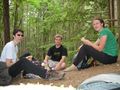
The trail up was quite distinctly up. There were switchbacks, and exposed tree root stairs, alternating with pleasant needle-covered packed dirt sections. It came out after ten minutes or so at a powerline right of way. Xore gazed up at the immense power pylon and remarked, "The things you see in the wilderness!" The trail continued a few hundred metres along the powerline right of way, then turned off onto another trail. It was even more up. We walked up, and up, and back, and forth. Robyn began to worry that she had suddenly contracted some kind of debilitating cardiovascular ailment, but the others assured her that she wasn't the only one puffing and sweating and feeling the climb. Rhonda announced that she had not eaten since lunchtime and had skipped her usual afternoon snack, so finding a place to eat would be a good idea. Before long we found a slightly wider spot on the trail that was suitable for sitting on, and had a brief meal break. Robyn had brought pepper goat cheese and black forest ham sandwich fixings, while Rhonda had packed chicken wraps. Two hikers came down the trail while we were eating, one of them using a pair of walking poles. We hoped the trail wasn't actually that difficult.

Much refreshed by the meal break and the fuel in our stomachs, we set off again, noting the elevation markers nailed to trees every 100m vertically. Our meal break had been at the 300 m mark.
The trail continued in a consistently upward direction until about 900m elevation. We had a few more brief breaks for purposes such as photography of a stunning overlook and to remove an object from someone's boot. The trail was narrow and steep but very well-maintained. We were fairly sure that we had started at close to 100m elevation in the parking lot, and were suitably impressed by our mountain-climbing abilities when we came out in the light near the summit.
The Junction
We reached a junction in the trail. We were now 750 metres from the geohash. The existence of a junction had been noted in the early planning and at the mapboard at the trailhead. We had carefully written down the name of the junction and discussion had already started on which way to go. One route followed the contour lines around the left of the peak, was longer in kilometres on the trail, and looped away from the hash point first, was probably closer to the hash point, but required bushwhacking around the lake. Xore supported that option. The route to the right was shorter, possibly more hilly, and required bushwhacking not around a lake. Rhonda supported that option. Robyn supported whichever option required less bushwhacking, but it was not entirely clear which route that was, because between the shifting names of the lakes and the lack of gridlines on the map, it was hard to see exactly where the geohash was other than between the two trail options right where they came closest to each other - maybe 200m apart according to Rhonda's hiking map. It was thought to be within 20 metres of the trail, but we suspected that distance might be in a swamp. Xore was even willing to bet a loonie (which he explained consists of a hundred pennies, and that's a lot) that the point would be in a swamp. After a bit more discussion, as the time crept towards seven 'o clock, Robyn voted for whichever option kept us moving, so picked the right fork and we continued. We also agreed on a turnaround time of seven-thirty.

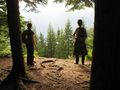
As predicted, this trail led away from the geohash, at times almost 180 degrees away, and it continued to be very steep. At one point there was a rope secured to a tree further up the slope to enable hikers to get up the grade. Robyn called out our negative progress on her still receiving GPS, and at 1.1 km from the geohash Rhonda speculated that perhaps this was not the trail, but just a path to a lookout. Wow, but what a lookout!
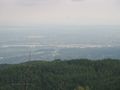
We'd come out at a rocky area where the view was not obscured by trees. It afforded a view of most of Greater Vancouver, from Pitt Meadows to Boundary Bay and west to the city of Vancouver. We were looking down at Simon Fraser University, which is itself on top of a hill so imposing that the transit buses can't get up it in the winter. We admired the view briefly, then retraced our steps to the junction.
Now that we looked, there was a placard on a tree that specifically did not match the name of the junction we had so carefully recorded, and which said in fine print at the bottom "not part of the Buntzen Lake trail system." We had now only thirteen minutes before our mandated turnback time, but decided to use those minutes going forward to see how close we could get. Maybe we'd be lucky and make the geohash after all.
The Other Trail

We turned down the correct trail and pushed the pace as hard as we safely could. We had now entered the "Lake District" so instead of the trail being treacherously steep, it was now treacherously muddy. At one point the trail seemed to become a creek bed, but after a dozen metres or so of following the creek bed we looked left and saw the real trail on the bank. We passed Wren Lake and Sisyal Lake, trying to run without falling and at the same time do mental calculations involving five minutes and four hundred metres left and the trigonometry of trail direction.
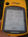
A few more turns brought us at seven-thirty to a small, unnamed and mosquito-infested lake 340 metres from the geohash. The expression on Robyn's face is not one of disappointment at not reaching the geohash, but of urging Xore to take the photo quickly so she can move away from the mosquitoes which have swarmed in glee towards her emanations of heat and carbon dioxide, in search of her blood.
The Race for the Car
It was 7:30, the gates closed at 9:00, and we had an hour and a half to get from our closest approach to the hash point down to the car before we were either locked in for the night or triggered a search and rescue response.
We walked as fast as it was safe to do so. The terrain was muddy and slippery near the lakes, so this was only a brisk walk. Xore tried to go a bit faster and ended up falling down, after which he only tried to go faster where it was drier. As we moved away from the lakes, the trail turned from mud to steep, and we were forced to maintain only a fast walk. Robyn fell down when she stepped near the edge of the trail half under a bush and found out the hard way that there was no trail there, but caught herself before sliding down the slope. Rhonda stepped on a slick root on a downslope and fell down with one leg folded underneath and her foot caught in a loop of root. There were no actual injuries, fortunately, only falls.
The trail was twisty and the trees got denser, and we frequently couldn't see each other, strung out along the trail as we were, so we stayed at least within earshot of each other by periodically yodelling or barking or singing, and listening for a response.

With 45 minutes left to go, we were just above 700m elevation, and still moving as fast as was safe.
With 30 minutes left to go, we were about 500m elevation, and getting a little worried.
Not far below our meal break spot, there were a few sections of trail that were nice and clear, and we started running, taking switchbacks on a downslope at high speed. After all that hiking, the running felt good.
Robyn yelled "trailhead!" and Xore and Rhonda, trailing, cheered, but it turned out to be the entrance to the powerline right of way. We still had a ways to go.
We alternated running and walking as the terrain allowed.
Robyn burst out of the real trailhead and saw the BC Hydro truck starting its sweep of the parking lot to chase people out before locking the gates, and sprinted for the car. The driver must have been satisfied that this car had an owner and that owner was preparing to leave, because he didn't stop to let Robyn use the excuse she had prepared, which blamed our lateness on Xore falling up at the top of the mountain and hurting his ankle just enough to make him walk slower than we needed.
As the BC Hydro truck disappeared into the parking lot, Robyn walked back toward the trailhead and saw Rhonda and Xore run out of the trees and toward the car.
As we were packing up, a car with a canoe on top drove toward the exit, and the BC Hydro truck made another pass near us, but didn't stop as we were quite obviously putting things in the car and getting ready to go.
The BC Hydro truck showed up a third time as Rhonda backed out of the parking spot, and a different truck followed us out of the park. We weren't the last ones to leave!
Tracklog
The tracklog is kind of funny because you can see the elevation change, the wrong trails, us hurrying up just before 7:30 to see how close we could get, and then us running at the end back to the car. The occasional weird spikes to the sides of the trail are from degradation of the signal in the trees. But as you can see, in general the eTrex Venture HC did an excellent job.
Photos
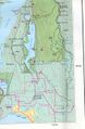
map
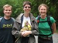
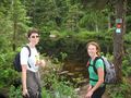
Geohashers ready to set out
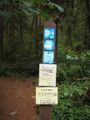
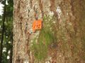
Bear presence warning at the trailhead
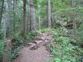
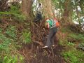
The trail was steep and narrow at places
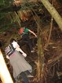
Stopping for food
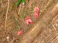
Red flowers we found on the way up
500m up, vertically halfway there
The lookout point
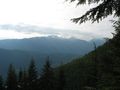
The View from the lookout point
More steep sections of trail
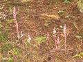
Some other red flowers we found near the top
View from the wrong lookout point
Climbing aid on the trail
As far as we got
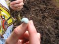
Robyn's Egg found right at the turnback point
One of the lakes at the top
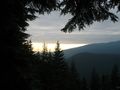
Sunset from the lookout point on the way back down
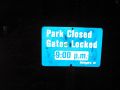
Photo taken at 9:04 while we are inside the gates
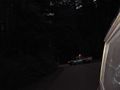
The lockup truck is behind us, so we know the gate is still open
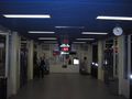
Seven minutes to spare to make the 10 p.m. SeaBus


