2009-07-18 49 10
| Sat 18 Jul 2009 in Bamberg: 49.9482294, 10.0370804 geohashing.info google osm bing/os kml crox |
Location
Today's location is in a small piece of forest not far from Rieden. The nearest bigger towns are Arnstein and Werneck.
Country: Germany; state: Bayern (Bavaria, EU:DE:BY); administrative region: Unterfranken; district: Würzburg rural district
Weather (16:00): clouded, sometimes rain
Expedition
Danatar
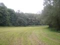
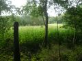
Most of the route I already knew, only the last ~800 m were new for me. I arrived next to the sewage facility west of the hashpoint at 15:55, only to find nettles, a creek and a fence blocking my way. And in that moment it started to drizzle. Since I didn't have much time left before 4 pm, I hastily started to cycle further along the track, hoping to find a possible way to the hashpoint. I was lucky, there was a bridge over the creek only a few steps further and the way was no longer blocked. I walked along a meadow until I reached the trees near the hashpoint. The last obstacle were a huge amount of nettles, both along the trees and in the uncut part of the meadow. I found a place were the nettle line was only a few plants wide, then I hacked them out of my way with my umbrella. Once between the trees I only had to go a few metres to the south to reach the hashpoint. It was exactly 4 pm now, so I quickly put Scotty (Scott, Hedgescott?) the Hashhog on a mossy tree and took a picture. Then I took the same way back. For part of the return trip it was raining, for part of the way it wasn't, I stopped a few times in dry places to let the worst showers pass.
Total distance cycled: 23.7 + 23.8 = 47.5 km. 430 m uphill
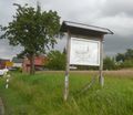
Rieden is a part of Hausen
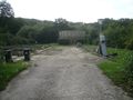
Sewage facility near the hashpoint
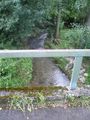
Creek
I did not wear long (enough) trousers
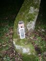
Coordinates reached just in time
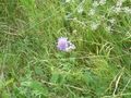
Melanargia galathea (Marbled White, the German name "Schachbrett" means "chess board")
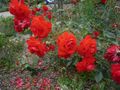
Roses are red, violets are blue, if you ask for a witty joke here I'll hit you


