2009-08-03 40 -89
| Mon 3 Aug 2009 in 40,-89: 40.4658008, -89.0357201 geohashing.info google osm bing/os kml crox |
Location
The geohash was on the intersection of two paths in a field on the west side of Bloomington, Illinois.
Participants
- Dvdllr & Rachel
Plans
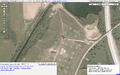
Little to no plans on this one! I ran the geohash webpage for the Peoria graticule at about 6:30 PM, and was on the road at 6:45 PM. I wanted to go because the hashpoint was on an accessible road/path, which is rare in this graticule because of all the farms. I printed off driving directions, an overhead view of the hashpoint itself, and grabbed my stack of Ambassador forms.
Expedition
Much like yesterday's expedition, I asked my dear wife to accompany me and act as navigator and photographer while I was behind the wheel. This expedition, however, was significantly more madcap than Sunday's, because whereas Sunday's expedition had been planned since Friday, this one's planning period was about five minutes. As stated above, I was eager to tackle this one because the hashpoint was not in the middle of some farmer's field, which is rare; additionally, it was on an intersection of two paths, which makes it easy for a guy without a GPS (like me) to find - it didn't require a compass or tape measure or sextant or anything. The final reason I was eager to go is because the Peoria graticule had not yet had anyone successfully reach a hashpoint, and I thought it would be pretty keen to be the first.
Arriving near the hashpoint, we turned into a gravel/dirt road that led into the general area. The main road went off towards the north, though the path we wanted went straight west. From looking at the overhead maps, I had thought these were more well-worn paths, but actually seeing them showed that they were two strips of gravel with grass growing in-between. I had originally mapped out a Tron-style route which would have required taking the car down this path, but I didn't want my little car to get stuck or cause any damage, so I left it down by the road and we walked up the path.
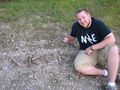
After we made it to the intersection, we took pictures of the site, a current newspaper, and made a little XKCD message out of sticks at just about exactly where the point was. We didn't linger long, and soon we were on our way back home. It wasn't apparent to me where exactly we were at the hashpoint - it wasn't obvious where these paths went or why they were there. There was a small building near the point where we came in, but it gave no indication as to what it was for or how the land was being used. I observed a few clues that indicated that no one had been there in a while: for example, the paths through the middle of the field (the ones we walked down) were overgrowing and apparently hadn't been driven over in a while; also, there was a bulldozer off to the side a ways, which obviously hadn't moved since they took the overhead pictures you find in Google or Bing, since it was sitting exactly where the maps show.
In any case, it was an exciting time - and now that I've completed a successful hash, I probably will limit myself a lot more to points near Morton and/or on weekends.
Photos
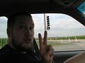
Attempt number 2, in as many days
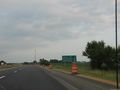
On the road to Bloomington from Morton
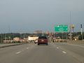
Downtown Bloomington
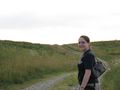
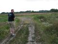
The lovely Rachel, on the path to the hashpoint
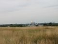
The field, with Bloomington in the background
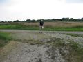
There it is, up ahead!
First successful geohash!

Ridiculous grin, and today's newspaper
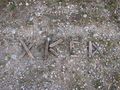
...was here.
Hooray!
Proof of location


Achievements
Dvdllr earned the Land geohash achievement
|
Dvdllr earned the No Batteries Geohash Achievement
|
Dvdllr earned the Graticule Unlocked Achievement
|