2009-08-04 51 8
| Tue 4 Aug 2009 in 51,8: 51.6550512, 8.4456251 geohashing.info google osm bing/os kml crox |
Location
A field just outside of Ehringhausen.
Participants
Expedition
Since I have been lurking this has been the first geohash close enough and on a day i actually had time. It was somewhere I have never been before so I took my dad's GPS, uploaded the rout from google maps and tried my luck. I decided to take a bit of a longer way home for the Tron achievement. The area of the hash point was encircled by a fence and my GPS said it was only 4 more meters anyway, so I decided it was good enough. I made the photos but before i could include the goofy smile photo the battery died (better always check the battery before leaving from now on). The way home was way more exhausting and took longer than I thought, and a lot of the way was through cities and on a motorway. But I got home save and was happy with reaching my 1st hash.
Tracklog
I had to recreate the tracklog in http://maps.google.com for the lack of knowledge about the GPS prevented me from logging the ride. The distance overall distance was actually a bit more because I had to cycle around a construction side in Schloß Neuhaus on ways I couldn't mark in maps.google.com thus resulting in 60 km of total way cycled. [1]
Photos
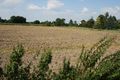
The field with the hashpoint
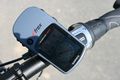
Just 4 meters? That's good enough!
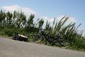
My bike and picnic. Sadly the battery died on me after this photo. *facepalm*


Achievements
El muerte verde earned the Land geohash achievement
|
El muerte verde earned the Bicycle geohash achievement
|
El muerte verde earned the Tron achievement
|
El muerte verde earned the Picnic achievement
|