2009-08-10 45 -123
| Mon 10 Aug 2009 in 45,-123: 45.6641552, -123.1047709 geohashing.info google osm bing/os kml crox |
Location
North of Hwy 26, West of Hillsboro, near North Plains, Oregon. The road to the hashpoint started out as paved, but promptly became gravel as I headed up the hill.
Participants
Plans
I was going to head there on my way home at lunchtime. It got somewhat delayed, but I did make it in the afternoon. I programmed the GPS, and wondered if the batteries would hold up, but failed to grab extra batteries for it.
Expedition
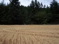
I went out to the hashpoint. It proved to be about 130 feet off the road into a now-harvested oat field. However, I felt it was prudent to attempt to seek permission, so I went to visit neighboring houses looking for the field owner. The first house wasn't occupied except for a dog outside that didn't seem to regard me as a threat, and also seemed unlikely as the owner. (The dog, however, was sure that the whole area was his.) The second house also had a very friendly dog, but had a friendly person as well. When I explained what I wanted to do, said that the owners wouldn't have any problems with that, especially since it was already harvested.
So, I ventured into the field and found the hashpoint. I took pictures, and escaped from the field, managing to avoid being impaled by what appeared to be rows of raptors.
Achievements
Jim earned the Land geohash achievement
|
Jim earned the Ambassador achievement
|
Photos
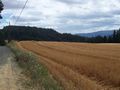
Pretty Scenery
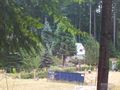
First house I tried to get permission at
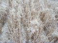
Raptor claws reaching out of ground

Yes, I made it
Towards the car, and safety


