2009-08-23 49 10
| Sun 23 Aug 2009 in Bamberg: 49.9003524, 10.0261624 geohashing.info google osm bing/os kml crox |
Location
Today's location is in a harvested field next to the Unterhof, which belongs to Hausen. The meadow next to the field is one of Unterhof's fallow deer enclosures and fenced in, but there were no animals visible.
Country: Germany; state: Bayern (Bavaria, EU:DE:BY); administrative region: Unterfranken; district: Würzburg rural district
Expedition
Danatar
Not long after arriving home from the 49 9 expedition I set out for the doublehash. I knew the route well from other expeditions except for the last field track before the hashpoint, so I was sure this would be a quick and almost boring trip. It started out as usual...
In Versbach I found a sign: "road works ahead, no bikes allowed". Oops. I knew there was another cycle track, with more slopes, somewhere to my right from Versbach and Maidbronn, but it wasn't shown on the printout maps I had with me. Failure was not an option, so I started to search for that cycle track. The first street was a dead end, next I decided to take the steepest street because I knew I had to climb that hill anyway. After 500 metres I could glimpse a field track not far ahead, but I wasn't sure and asked an old woman for directions to Maidbronn. She send me back to take another street at the last intersection I had passed. Looking at the map now shows that the field track I had seen would end dead after another ~800 metres. Phew! The street the woman had indicated climbed steadily, with a Via crucis at the side, until I reached a small chapel. I continued ahead and down to Maidbronn. Because I knew that the cycle track would continue but I couldn't see details on my low resolution map, I took the streets that were going in the same direction I was already travelling, uphill out of Maidbronn, and finally I reached a road I knew. From there it was the well-known route until the last part before the hashpoint, in fading daylight. The field track near the hashpoint consisted mostly of grass, with patches of packed dirt in between, but I finally reached the spot. Until then I had navigated by maps and when I switched on the GPS in the middle of the field I was only 8 metres from the correct coordinates. Yay!
By now it was dark and I soon started back. I saw the fallow deer raised for meat at the Unterhof despite the darkness but they ran away when I stopped to take a picture. Only my small bike lamp lit the way home but now I knew where to go and I could race along the field tracks through the cold darkness. 200 metres from home, just after Nancy (and Frank) had told me "I love you", my mp3-player's battery died, does this count as "perfect planning" or as "you are doomed"?.
Total distance cycled: 17.9 + 16.6 = 34.5 km; 460 m uphill

Sunset. The hashpoint is still far away
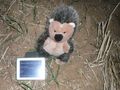
Coordinates reached
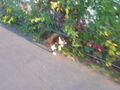
This cat saw me and then ignored me. But when I cycled by it it JUMPED!

More cat

And more. 4 others were out of camera range by the time I got it out of my pocket.


Danatar earned the Multihash Achievement
|
P.S.: This is Danatar's 1337th edit. SPAM!