2009-08-28 40 -105
| Fri 28 Aug 2009 in Fort Collins, Colorado: 40.4996837, -105.8026864 geohashing.info google osm bing/os kml crox |
Location
On a hill overlooking Long Draw Reservoir, inside of the Neota Wilderness boundary. The elevation according to a topo map is 3243 meters (10639 feet).
Participants
Plans
I'd been watching coordinates this week and this day landed above 10000 feet. It seems Google doesn't know how to give good directions from zip 80027 to this hash. While I've been wanting to drive Trail Ridge Rd, I wasn't up to driving over 15 miles on a ditch road! Besides, the road is also closed to public travel. The Forest Service has Motor Vehicle Use Maps (MVUM) available which can be used to navigate these areas. I intended to leave work early, but after looking up all of this I ended up leaving work at 18:00.
The plan? Go home, eat, pack, leave as soon as possible. Travel north to Fort Collins, then west to hash via state highway 14 (Poudre Canyon Hwy). Google estimates 3 hours 48 minutes via this route.
Expedition

I arrived at Long Draw Reservoir at about 11pm, leaving only one hour to climb the hill in the dark. I quickly stuffed my pack, strapped on my sleeping bag, and set out. So quickly in fact that I forgot to roll up all of my car windows, but fortunately nothing more than dust got in. After about ten minutes of clinbing I started to wonder what I was thinking. After half an hour, sitting at the bottom of a rock face, I really wondered. I took a good look at the GPS and saw how close I was, so I pressed on.
At about 23:45 I managed to find a safe route to the top. Climbing in the dark is certainly more difficult than when it's light, especially when you have one less hand due to the flashlight. Ok, now the easy part, right? It's only 20m away. Closer, closer, and then I felt that bad feeling of my foot sinking into soft ground. Ugh. Back up a step and take a better look around. Hmm, water. Let's go around the edge on solid ground and hope the coordinates aren't in the middle. Whew, a few handy stones to step on and I was at the coordinates without any extra water in my shoes. Time: 23:56:32. It took a few minutes to unload and get the camera out of my pack, so the photos are just after midnight. Wait a second, I get a Midnight Geohash achievement! Now the goal, highest geohash: GPS elevation reads 3250m, but I'll take the topo map value of 3243m as the official number.
I picked out some solid ground only 16m away and unpacked my sleeping bag. Morning revealed the large puddle, or small pond, I started to step into, scenic views, and birds that didn't seem to know what a human is. I spent a while taking pictures, then made the decent back to the car. Along the road back to the highway, I was able to observe a pair of moose for a bit.
Tracklog

Achievements
Cedar Myers earned the High geohash achievement
|
Cedar Myers earned the Midnight Geohash achievement
|
Photos
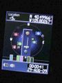
GPS at hashpoint. It took me a few minutes to pull out the camera so the photo is after midnight.
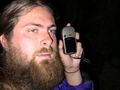
Me... tired.
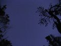
The sky I slept under.
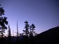
The view before sunrise.
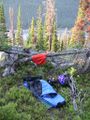
Where I slept.
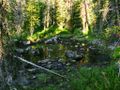
Large puddle or small pond?
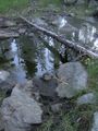
If you look closely near the bottom you can see where my foot sunk into the mud.
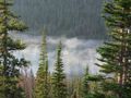
The view in the morning.
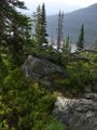
Another view angle.
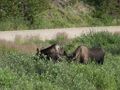
The moose I saw on my way back.


