2009-09-01 49 -123
| Tue 1 Sep 2009 in Vancouver: 49.8609535, -123.1742303 geohashing.info google osm bing/os kml crox |
Location
In the Paradise River Valley, near the river, about 200m from the road. And google terrain shows that it's flat!
Participants
Planning
Going to drive there after work. Leave North Vancouver at 6:30PM, estimate parking at closest approach about 8PM. Bring flashlights, it's in a valley and right around sunset. There are currently three empty seatbelts available.
(Yeah, I know, driving. But it's been a while since a successful hashpoint, and I've never been down that valley before.)
Expedition
Twas a dark and stormy night...
Rhonda & Xore left North Vancouver at about 6:45, sadly with no other geohashers taking up the offer of empty seats. Traffic was light and so was Olympic construction on highway 99 "Sea to Sky"; one lane in each direction for extended sections but not a lot of activity.
After about an hour and a half of driving, as predicted by Google Maps, we pulled off the highway at the Squamish Airport turnoff and down a few twisty side roads, surrounded and covered by a tunnel of trees, crossing a one-lane bridge and then continuing onto a dirt road. Xore's GPS eventually drifted down to a local minimum at 281 metres from the hashpoint. Our heroes parked the car in a slight wide spot in the road and set forth into the twilight gloom.
A driveway and a house to the side of the road seemed like a possible route to the hashpoint, however approaching a house this far back in the woods near dark seemed like a dangerous proposition. Instead, we found and followed a trail through the woods that led directly west towards the river, and the hashpoint. We were fortunate to have the trail, as the GPS lost reception a few times along the trail, leading to some gaps in the tracklog. Google maps showed the hashpoint on the east bank, however the river's twists and turns seemed beyond the predictive abilities of Google cartographers. The hashpoint, it seemed, was right in the middle of the river, 40 metres downstream of where it plunged off a rocky beach into the forest.
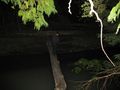
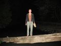
Undaunted, our heroes plunged into the forest as the sun set behind the misty, tree covered mountains in the west, or the east, or whichever direction the sun sets behind. Following the river through the forest, Xore discovered a large tree which had fallen across the river. Dropping his backpack, he followed his GPS out over the water. Dropping his shoes on the beach on the opposite side, he waded into the cold water to try and get the GPS to show arrival. Rhonda followed with the camera, but the poor signal reception under the trees at the bottom of a valley meant that the GPS had changed its mind about the hashpoint location again and was now directing us back the way we had come.
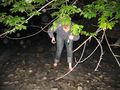
Xore collected his shoes then we crossed the river on the log again. While Xore was putting his shoes back on, Rhonda watched the GPS wander all over the landscape, ranging from 3m to 15m from the hashpoint, all without her moving. A few attempts were made at picture-taking, but every time Xore got close with the camera, the GPS thought it had moved away from the hash point.
Once all required belongings were collected, we realized that we were no longer in twilight but in the full dark of night. Fortunately, we had correctly predicted this effect of the sunset time, and had brought a flashlight each. Unfortunately, navigating underbrush in the dark with only a flashlight and a GPS that keeps getting confused about where it is, isn't the easiest of tasks. Fortunately, we knew that if we kept the river on our left and kept it close, we'd get back to that rocky beach and from there to the trail that had led us in.
After some stumbling around, we found the very tip of the rocky beach and scrambled over a fallen tree to jump down rather than continue fumbling our way to the route we had taken into the trees. The GPS helped us narrow down the search area for the trail back out and we confirmed that we had the right trail by the steps built to help hikers over a fallen tree. On the way out, we recognized various landmarks like the branch that Xore nearly walked into and the other branch that snuck into one of Rhonda's pictures, which was reassuring because the GPS showed us quite distinctly not following the same track we took to get in. It wasn't long before we came out of the trees, got ourselves through the ditch and back up on the road, and located the car, right where we had left it.
Without the river and the trail to assist, the GPS would have failed us and we would have had a much harder time getting through the forest once full dark arrived. Rhonda thought partway through that she should have grabbed her car's compass before setting out, but it worked out in the end.
(Photos to follow.)
Photos
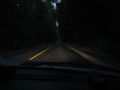
Tunnel of trees en route to hashpoint
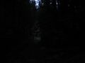
Off the road, down the dark narrow path through the trees
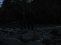
On the bank of the river
Xore out on a limb -- or a log
Rhonda on the log over the river
Wading barefoot in the river past dark
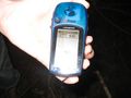
Hashpoint coordinates reached

Rhonda on the log checking GPS by flashlight

The moon came out of the clouds a bit on our way back


