2009-09-02 40 -105
| Wed 2 Sep 2009 in Fort Collins, Colorado: 40.2813819, -105.3347528 geohashing.info google osm bing/os kml crox |
Location
On a hill, in a forest.
Participants
Plans
Not really, but I did look at some maps. Plan A, approach from the south-east. Plan B, approach from the north-west.
Expedition
Plan A: Private property. Go to Plan B.
Plan B: Private property. Explore...
Plan C: Oooh, look, a National Forest Property sign. What a welcome surprise. Let the adventure begin. Over the river and through the woods to the hash point we go.
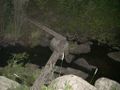
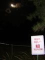
I parked the car near the National Forest Property sign and packed by bag. About 50m from the road I stepped on to a trail. It seemed to go the direction I wanted to, so I followed it. It was dark, but the moon was nearly full so I didn't use the flashlight much. After a while I decided that this was a well traveled human made trail. When I got to the stream at the bottom of the valley, I crossed a bridge of sturdy boards bolted into the rocks. I made the climb up the other side and eventually left the trail towards the hash, but ran into a fence with a private property sign. I back tracked a bit and went further east. Up a hill, down a hill and through a field, I arrived at the hash point. No fences, no private property.
Snap some photos, drink some water, set the course back. After 100m or so I walked onto a "road", two ruts. Following the road led me to a gate only 20m from where I had found the fence and private property sign. It's amazing what you can miss in the dark... :)
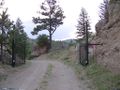
Over the gate and down the trail, I decided to leave the trail again for a "short cut". Well, it was shorter, but I wish I had stayed on the trail. I battled my way through the fallen trees and undergrowth, back down to the stream. No bridge, but some convenient rocks. Cross the stream, back up the other side to the car, tired and thirsty.
Tracklog


Photos
First no trespassing sign
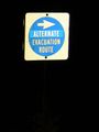
Interesting sign
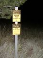
National Forest Property Boundry
Signs of civilization
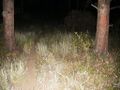
The path
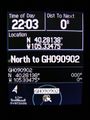
GPS

Stupid grin
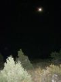
The view
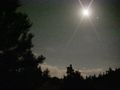
(That's the moon)
The gate


