2009-09-08 48 8
| Tue 8 Sep 2009 in 48,8: 48.4722325, 8.5345979 geohashing.info google osm bing/os kml crox |
Contents
[hide]Location
Near Dornstetten, in a dense and wet part of the Black Forest
Participants
Expedition
About two years ago, the idea to go by bike into the Black Forest, and maybe even back, was somehow alien to me. But once you actually check the options, you'll find a way. And once you actually test your limits, you'll push them. So, one month after the first run deep into the mountains, a second one followed. And as I found, it wasn't so hard anyway. There have been other trips which looked closer and easier, but actually weren't.
There seemed to be basically three reasonable ways to get to the hash:
- through the Oberes Gäu hills and via Hochdorf along the ridge to circumvent both the Neckar and Nagold valley, the shortest one
- through the Neckar valley and Dießen valley, the easiest one
- through the Neckar valley and Glatt valley, a significant detour, but probably nicer
I chose the first option, varying the past few trips a little bit to add more tracks to OSM, and went for a geocache which I already did not find twice until I realized that the cache had moved since I had copied the coordinates. Well, these two goals didn't really agree to another, and at some point I noticed that I would have to go back for about a kilometre because there was no connection between the way I was on and the one which lead to the cache. I went on instead. There will be another chance.
After about two hours and two caches I actually found I had reached Hochdorf, and with that, the Black Forest. I decided for a route through Altheim, Grünmettstetten and Tumlingen, mostly because I had never been in that valley before. Actually, it didn't turn out to be the very best idea - you should always compare the exact elevation profile when planning a route along here. I found quite nice landscape, but nothing particularily spectactular.
Around 3 pm, I had reached the patch of forest where the hash would be, somewhere in the upper parts, and went on the last significant climb. I ignored the fact that the tourism managers had declared this place to be a wellness forest, and also ignored the meditation places along the way. Instead I went for a Blair witch project cache, which was supposed to be located on a small clearing which, well - really fit the theme. Not the wellness theme, of course.
This took me longer than expected, because I did not find the cache. I totally failed to make the spoiler picture agree with reality, and didn't think it would help to change reality to agree to the picture. As I found later, not only the coordinates were a bit off, but also the pictures were 7 years old, so reality had probably changed itself to disagree with the pictures. Bah. However. After almost half an hour I finally gave up, went further up, and tried to get as close to the hash as possible on decent ways, which was about 100 m.
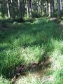
The forest was rather dense here, also very wet, but a muddy logging aisle provided something that was good enough to get in there. A few more metres into the underbrushs, and I had reached the hash. Nothing to do there than catch a proof, though.
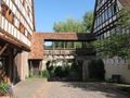
Today's hash town was Dornstetten. Dornstetten is a small but touristically well-known town, both for the surrounding landscape and the old city with a lot of preserved traditional half-timbered houses. Although it was getting rather late, I finally decided to take the longer route through there, and then along the Glatt valley - not only because there is more to see there, but also because one of the villages along the way would make a great spot for a special release in an ongoing bookcrossing challenge: For the occasion of oncoming date 2009-09-09, this was about the number nines, and Neuneck actually means "nine corner" (although it probably derives from Neueneck, which would be "new corner").
I hadn't checked out exactly how much of a detour this route would be. Given that the valley not only went in quite a wrong direction first, but also was very curvy, it turned out to be a heck of a detour. So although keeping the stopovers short, I reached Horb not earlier than around half past six. Another 38 km would bring me home from there, but that would take at least about two and a half more hours, including reasonable stops, and it was about to get dark in one and a half. I stocked up on food and left Horb again a few minutes before seven, trying to at least to make ten more kilometres to Eyach station because the ticket from Eyach is less than half the price of one from Horb. When I got there, a train was due in less than ten minutes, and nightfall in less than one hour, so I gave up at that point and caught the train.
Gallery
I made one photo at every full hour (give it one or two minutes), no matter where I was at just that time. So those photos are pretty random, but give a good representation of where I passed.
At 9:00 I had just left home and was about to leave town.
At 10:00 I found there was no way to the other side of this "valley", and took a route on this side.
We're on a road to nowhere
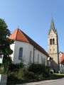
At 11:00 I stood in front of this church at Baisingen
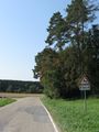
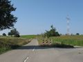
At 12:00 a sign warned me that there might lure kamikazeous deer around the corner.
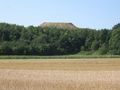
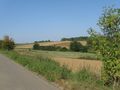
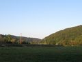
At 13:00 I found that, given the elevation profile, this route wasn't actually the brightest idea; and wondered what that heap in the background may be
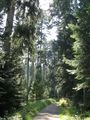
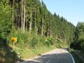
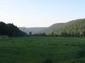
At 14:00 I rode through a deep forest valley and decided to go for another detour
Something almost, but not quite, entirely unlike a way.
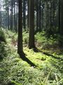
At 15:00 I was at the hash. Exactly.
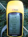
Coordinates reached (given the usual GPS dance)
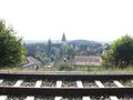
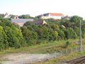
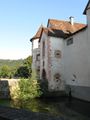
A first view on Dornstetten
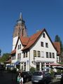
At 16:00 I stood on the market square of Dornstetten and thought about getting some ice cream at this cafe.
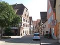
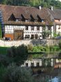
More impressions from Dornstetten
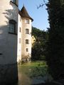
At 17:00 I was down in the Glatt valley and just left the village of Neuneck
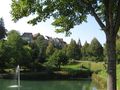
Castle Glatt
At 18:00 I just had reached the Neckar valley
At 19:00 I had left Horb and wondered whether I would catch the 19:31 train at Eyach.

At 20:00 I came home.


