2009-09-28 48 10
| Mon 28 Sep 2009 in 48,10: 48.4664166, 10.1743325 geohashing.info google osm bing/os kml crox |
Contents
[hide]Location
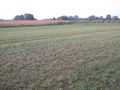
A meadow at Langenau (Württemberg), although closer to Leipheim-Riedheim. Very close to the bavarian border.
Participants
Expedition
The idea
Doing a bicycle multihash had been on a top place of my hashing wishlist for months.
The closest a multihash can get at latitude 48.5 is 73.5 km as the crow flies - if you start with a couch potato. You usually won't do that, and since in a mountainous area like here roads never go straight in east-west direction, the actual distances will get significantly longer. I had laid out a number of reasonable routes from nearby places to their respective counterparts in other graticules: They started with 120 km over the Schwäbische Alb mountains to the east, or 140 km over the Black Forest to the west. One way distances, of course. Both of them would require to push my limits a bit. I had only once reached 120 km on one day before, and that had been quite some time ago and in easy terrain. Anyway, after three expeditions of more than 100 km in rather worse terrain, I knew that I could do it. I would only need enough time, acceptable weather, and a good set of coordinates.
And that was where I was running out of time: Days currently are about 12 hours from sunrise to sunset, a number that is rapidly decreasing for oncoming winter. Temperatures dropped below 5°C recently. Fall will bring storm and rain.
These coordinates weren't perfect. It was a bit further to go than necessary, and it was the eastern route, while I had preferred to go west. But: Both hashpoints were almost certainly accessible. Flat terrain on the second half of the trip. Weather forecast: Dry, mostly sunny, 10-20°C in the valley, three less in the mountains, wind no more than 2 Bft. These conditions probably won't get any better before next year. There were no excuses. This might be the last chance for months.
The start
I got up early enough to leave even before sunrise. However, my bike has a number of small issues that aren't critical if you have the appropriate tools with you, but fatal if you can't stop and readjust if necessary. And there was a problem: One of those tools I couldn't find. I panicked and searched on. And finally decided I would just hope I won't need it. Also, there wasn't any bread for a decent breakfast, so I skipped that as well. Finally, it was 7:20 in the morning when I hit the road.
To the first hash
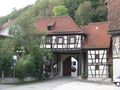
Hash #1 was about 15 km from home, on a rather hilly route I mostly knew. There actually had been an earlier hash in just the same forest, a bit further up, in winter. When I drew those tracks for OSM that time, I could only guess which surface there was below the ice layer. This time there luckily wasn't any ice. Shortly before 8, in the village of Ohmenhausen, I found an open bakery and stopped for breakfast, then continued into the forest.
About 100m from the hash I parked the bike and walked into the open forest. Got spoiled by some significant mud, but was able to cross that balancing over a fallen log. 8:33 - coordinates reached #1. Back to the bike and on it goes.
Up into the mountains
Now I found what I hadn't brought: A decent map of this forest. All I had was a small OSM printout without elevation markings and a vague idea which direction would be right. Trying to keep a certain direction in a hilly forest isn't actually the best idea, but surprisingly I came out of the forest at exactly the place I had aimed at, close to an extremely rare thing: A phonebox of the 1950s model, still in daily use. This might be the last of its kind, and I actually had promised several people to document it when I get a chance...
Took a number of photos, then tried to take a route that neither led through the inner city, nor up on the Georgenberg. Failed, halfway climbed that mountain just to go down again immediately. Ended up carrying the bike down some stairs to make sure I'll get back on track, down in the Echaz valley.
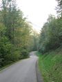
The Albtrauf steep slope is the unavoidable hardness on any trip to the south and east. To avoid boredom, I didn't continue on the easiest route but on one I never got to take before, the Göllesbergsteige. This one turned out to be a rural single track road, with an incline of just above reasonable for me and my lack of low gears. I should have taken it easy and pushed the bike, instead of risking any significant exhaustion 100 km from the destination. Instead I sneaked upwards at an average of about 6 km/h, finally reaching the ridge about 20 minutes past 10.
Over the Alb
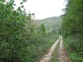
The route planner had recommended another route, but I gladly swapped another 300 elevation metres for not more than 5 km of additional distance. Although, once up, the Alb isn't much of mountains but more of an elevated hills area, there aren't many easy trails there. This is mostly because there aren't many rivers you could follow, instead you usually have to go over the hills and through dry valleys. So choosing a route was easy. There was the one valley between Münsingen and Schelklingen, along the railway line - well, actually railway engineers of the 19th century had to deal with the same problem.
65 km, mostly along secluded agricultural tracks, took me all over the mountains and to Blaubeuren.
Blaubeuren
A guide I had taken a look in when preparing the trip claimed that you simply can't visit the area without visiting Blaubeuren. The problem with that statement is, that I agree. So, when I came close, I decided there would be enough time to take a detour and take a few photos at the Blautopf at least. This decision wasn't based on any hard facts, though.
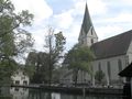
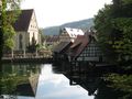
Blaubeuren is famous for a number of attractions, the two most important being a well-preserved medieval monastery, which is until our days partly used by a college; and the Blautopf lake, source to the river Blau and the second strongest source in Germany, fed by underwater streams through a vast system of flooded caves, home to a good number of fairy tales, the best known probably the story of the Schöne Lau, a mermaid who was confined here by her husband for not being able to laugh.
Blau means blue, Blautopf is a pot of blue or a blue pot. It's nothing special that water is associated with the color blue, but usually that's just mirroring the sky. Not so with the Blautopf - its water actually is blue. See the picture below. It's not any mirroring, algae or bad white balance, but a special type of dissolved limestone.
Down along the blue river
After about half an hour I moved on. I didn't have any exact idea how long it would take me to the hash from here, but I had the strong feeling that it could be too long. However, I now had reached the well known Danube valley cycle trail, which I could follow to shortly before the hash, and should make things much easier. Actually I wasn't in the Danube valley yet, but for reasons stated above the trail splits up at Ehingen, with the recommended route via Blaubeuren instead of along actual Danube river.
This went well until I reached the outskirts of Ulm, where I must have missed a sign. So I just followed some signs to the inner city, then to Neu-Ulm. Ulm has a reputation to well maintain their cycle routes, so there wasn't any doubt that this would take me through the city on a somehow reasonable route, and I'll see on the tracklog where I actually had been. Crossed the Danube, and with this the state border, on a large motorway bridge with a bad excuse for a bike lane. Actually, when I stopped to make a photo, someone came with a childrens trailer from behind. And since it was absolutely impossible to pass, I quickly packed everything and moved on instead of causing major traffic congestion.
Along the Danube and to the hash
The good news: The Danube would provide a good line of orientation for the rest of the trip. The bad news: It didn't provide a continuous trail along the river, and although the timing wasn't too bad, it neither allowed for any significant delays. The signage for the Danube valley trail got a bit ambigous, which probably was mostly because they only considered this one as a variant, with the main trail running more off the riverside. My maps were incomplete or outdated, which meant that I ran into an unexpected industrial area, crossed the river on a bridge that had actually been relocated, and didn't always exactly know where I was. At some point, it seemed to be a good idea to leave the riverside. This took me to the hamlet of Weißingen.
Attention! Due to road construction on the road between Weißingen and Riedheim you will meet the school bus on this track. Oh? That means... if the school bus gets rerouted over forest tracks, it might be a good idea to take the same route. It actually was.
The hash was near. Crossed the motorway on a bridge that isn't there on the google aerial imagery, and left the road about 500 m from the hash to continue on an unpaved agricultural track which ended about 150 m from the hash. The field the hash was in turned out to be a meadow with only short grass, so even cycling on it was possible.
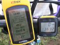
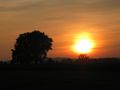
18:45: Coordinates reached. I had made it, after eleven and a half hours of travel time including stops, just in time to get to the next town at sunset.
Technical data
- Start: 7:20
- Hash #1 reached: 8:33
- Hash #2 reached: 18:45
- Overall cycling distance: 156.28 km
- Train back home: 135 km
- Lowest point: 330 m (home)
- Highest point: 765 m (Ohnastetten)
- Total of uphill slopes (elevation gain): 770 m
Gallery
Again with hourly more or less random photos.
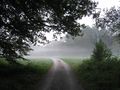
Early morning in the valley
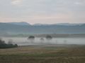
Early morning in the hills

8:00
Breakfast at a bakery at Ohmenhausen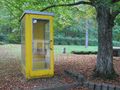
Ancient type of phone box. Possibly the last one of its kind in use outside of a museum!
9:00
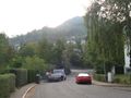
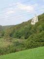
Trying to get around this mountain. Half-failed.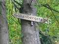
This way up.
10:00
Climbing up the Albtrauf on a minor road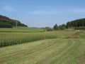
11:00
Taking the lower route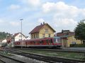
12:00
At Münsingen. This train only goes to the next two villages.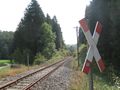
Rural railway track - One train on schooldays.
13:00
Down the Schandental valley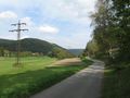
14:00
Between Schelklingen and Blaubeuren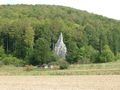
The Space Shuttle was not an american invention. It was brought by aliens millions of years ago.
15:00
Blaubeuren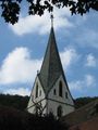
Blaubeuren monastery church
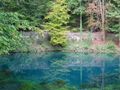
"Blue pot"
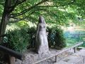
The Schöne Lau
River Blue
16:00
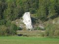
Random rock impression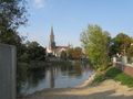
17:00
View from Neu-Ulm over the Danube on Ulm Cathedral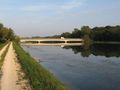
Along the Danube
18:00
Further along the Danube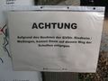
Attention! Due to road construction you will meet the school bus on this track.
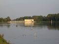
The hashpoint
Coordinates reached
View from hash

Back home from the station of Langenau...

... which on the other platform was renamed.
Run!!!1
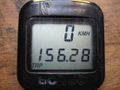
Trip odometre total for the day


Tracklog
...is here.