2009-10-02 48 8
| Fri 2 Oct 2009 in 48,8: 48.5598731, 8.9992145 geohashing.info google osm bing/os kml crox |
Contents
[hide]Location
In the Schönbuch forest, close to the Saurücken area above Ammerbuch-Entringen. The hash is located only a few metres off the paved way from Entringen to Bebenhausen, on a gravel track, which means easy accessibility. Nearby features: Lots of trees, various game, childrens playground.
Users of public transport can go by train to Entringen or by bus to Hagelloch Dornäckerweg and walk the rest (about 3.5 km on easy ways).
Participants
- Ekorren was there in the afternoon
Expedition
This was a rather easy expedition: Mostly on paved ways, only short parts gravel, no off road parts, only acceptable slopes. Not much to tell either, since most of what was along the way already was part of earlier expeditions.
As planned I went there by bike, basically on the standard route via Bebenhausen through the Goldersbach valley, then up the Arenbach valley. There was nothing spoiling the ride, I just took two small detours.
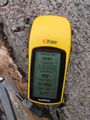
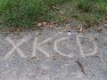
The unavoidable GPS dance left open whether the hash was actually on the track, or at the side at a stack of logs. Didn't bring a marker, so I marked the gravel of the track.
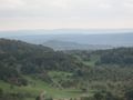
Took another detour to check out a viewpoint I didn't know yet. The view really was great, the continuing way was a bit more of a detour than I had expected, but I wasn't actually in a hurry. Went back through the Ammer valley.
Gallery
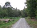
The hash point is somewhere here
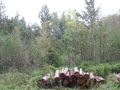
Maybe here
Or here
Or here
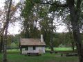
A witches house
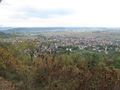
View on hash village (Entringen)
View to the Wurmlingen chapel. You can never get enough of those.
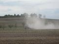
Not burning. It's only dust.


