2009-10-28 49 8
| Wed 28 Oct 2009 in 49,8: 49.1428565, 8.1476322 geohashing.info google osm bing/os kml crox |
Contents
[hide]Location
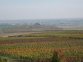
A beet field at Rohrbach (Pfalz). Just as spectacular as it sounds.
Participants
- Ekorren was there.
Expedition
Basically, I was determined to go hashing that day, no matter what - since it would be the only chance for a hashiversary ribbon for a year. However, when the coordinates came out, I wasn't so sure any more. They were all far away and not very interesting. Finally I decided for the Mannheim graticule, the main reason being that that would also complete the minesweeper achievement for my home graticule.
I got up hardly after going to sleep, and caught a train at shortly before 6 am. Unlike the one half an hour earlier, this one would allow me to get off at Eyach and buy the daypass I needed without actually leaving the train and waiting for the next one - while the train waits for a passing one.
The closest station to the hash was the one of hash village, Rohrbach (Pfalz). However, I could take a faster train which doesn't stop there and get off at either Winden or Landau, arriving there half an hour earlier than at Rohrbach, continuing by bike; which probably wouldn't be slower.
I was wrong about the latter. When I had arrived at Landau, I wanted to take a quick glance at the town and totally underestimated the time it would take me to actually find the best way out of town after that. I also found myself doing some detour because the way I had aimed at wasn't there (or I missed the intersection), and was somehow wrong about the terrain - what had looked like basically flat terrain, was actually a sequence of annoying uphill and downhill slopes.
Not far from the way I was on now, there was one actual sight: Some leftovers of a huge line of Nazi/WW2 fortifications securing the western border against France. They never really got into use, though. No pictures, because it was all totally overgrown, so you wouldn't see anything but bushes. Being there, you see a lot of concrete.
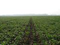
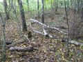
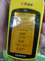
Now, going out for the hash. I missed the place where I should have turned away from the motorway and then there wasn't a right turn for about a kilometre. Finally found some bad agricultural track, followed that, and it luckily got better soon. Came close to the hash by about 200 m and found a huge beet field, but there was still home that from the other side it wouldn't be so far into the field. So I circled it, and got until about 70 m. Taking a closer look at the field, the rows seemed to be planted in a way that it would be possible to walk in there without harming any crop, and so I did.
Beet plants to the left, forward, to the right and back. Everywhere beet plants. Well, I shouldn't complain, given my own consumption of sugar. And that's what they make of it here. Yes, for those who live in other places of the world: ALthough sugar is usually made from cane, a few countries in Europe produce their own sugar from beet.
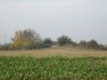
Coordinates reached, now how to make that an interesting expedition? I had decided for some bike trip to the most northeastern point of France, and why not just start from here. Went through the hills of the southern Pfalz region, one of Germany's main producers of wine. Unlike more to the south in my state, where grapes are usually only grown at steep southern slopes of the hills (to make them collect more sunlight), they grow them in large fields here, regardless of direction and sun exposition. I have actually no idea about the quality of the wine, I don't drink it anyway. Those wine plantations gave a fascinating view in that they were striped as they grow different types, and the different plants seem to behave differently in fall recolouring.
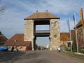
I was much slower than I had expected or planned, for two reasons: One, as I found during the day, I didn't actually really feel well, which cut down power significantly. Two, again, the terrain was not almost flat but rather annoying. Went through Bad Bergzabern which looked worth seeing but I ran low on time; passed a number of old villages which didn't only advertise local wine at every corner but even smelled after wine, and reached another point that was marked as a sight on the map: The German Wine Gate.
The german word for a touristical sight is Sehenswürdigkeit and means: Something worth seeing. Sometimes you get there and actually think, although the english word fits, as there is something to see, the german word doesn't. And that way it was also with the Wine Gate. An entirely non-spectacular monument, some stupid decorations, some wine and souvenir shops, and a good number of tourists. There should be a viewing platform. I climbed it, and found that it only led halfway up, not high enough to actually get a good view over the landscape. Been there, done not much, leave it and forget about it.
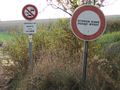
The border to France was among the first borders which were opened with the Schengen treaty. Nowadays, it basically doesn't exist any more. The sign shown in the gallery below actually shouldn't be there - and you are better off just ignoring it, since it would forbid you to take the recommended bike trail...
Wissembourg, a small town shortly behind the border, is also among those which are worth a stroll. When I planned the tour, I had hoped to be able to spend an hour or two here, but I was far too late for that. Rather, I wanted to go further on by bike to Lauterbourg, visiting a conveniently located degree confluence along the way, so I moved on, somehow found my way out of town. The confluence point was in a forest, only about 20 m from the bike trail. Of course there also was a cache (a surprisingly large one), but that basically was all there was.
That trail was on a former railway line, which had been built in 1900 mostly for strategical reasons, and closed down already in 1947. And here, this actually meant that it was flat terrain and mostly straight, so I should have been going with a good speed, given that I still was far below the distance of other bike expedition. But as said before, I didn't really feel well. Rather, those last 15 km to get to the station at Lauterbourg were pain. But there wasn't really a choice - I had to get there, and catch the train at 17:45, so I forced myself to keep going. When I reached the town of Lauterbourg, I found some spare time to buy some french food. And even a bottle of regional wine - for my mother.
Gallery
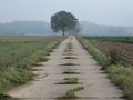
Way to hash
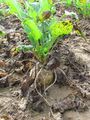
The hashplant
View from hash (wide angle)
View from hash (tele)
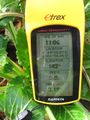
Coordinates reached
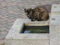
Trying to catch some fish?
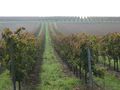
Typical wine field
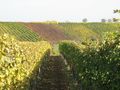
Stripes on the hills
The German Wine gate
I don't speak french.
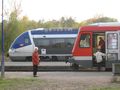
International train traffic at Wissembourg
The 49,8 degree confluence point
Confluence coordinates reached (with the usual GPS dance)


Ribbons
Ekorren completed the Minesweeper Geohash achievement
|
Ekorren earned the 1st Hashiversary achievement
|