2009-11-06 34 -107
| Fri 6 Nov 2009 in 34,-107: 34.1107714, -107.4648176 geohashing.info google osm bing/os kml crox |
Location
Behind a few small mountains just northeast of the VLA.
Participants
- Redaragorn and 3 yr old son
Plans
I woke up knowing this was gonna be a drive and geohash kind of day, so I headed out at 7:30 to see where the Internet was telling me I should go. Based on where the geohashes fell, I figured I could finally catch the Magdalena hash after considering it for quite a while (and even attempting it once or twice). While I was heading south and west, I looked a little further along US 60 and realized that the Quemado hash looked eminently accessible as well. I'd been wanting to get to that area anyway, so I was eager to get out there. To top it off, I could get the triple virgin graticule day by catching an easy hash in the Gallup graticule. Let's do it!
More specifically for Magdalena, though, I saw that there was a stock tank around a mile from the hash that had access roads leading to it that appeared to be in good shape from the satellite photos. There was another road to the east of the mountains, but it was longer and appeared to be less-maintained. I opted to drive past the hash and take the west road around the mountains, then cover an easy, level mile to the hash. I was a little confused as to land ownership, though. The Google map had it marked as National Forest land, but the BLM surface management map and my atlas showed it as private land. I figured I'd take my chances and see how it went.
Expedition
On the drive west from the town of Magdalena, I noted that the east road I'd seen on the satellite maps was gated and marked as a private ranch, so I wasn't terribly encouraged. I got around to the west road and was greeted with a Road Closed gate and sign. Uh-oh. I had noted a rest area due south of the mountains, so I figured that as a final shot I'd head back there and see how close I was to the hash at that point. I drove back around to find that I was still 2.5 miles from the hash point, but I took it as a good sign that there was a hiker gate in the barbed wire fence. Hmm. No "No Trespassing" signs in sight...let's go for it! I got myself and the boy ready for a hike and we headed north. I aimed for the gap in between that two mountains that looked on the topo maps to be a fairly easy passage through, then I could curve back around and catch the hash on the northwest side of the mountains. And the hike went pretty much just like that. Except that the boy tired quickly (it was pretty much nap time when we started), and he kept getting stickers in his feet. I put him in the backpack pretty early to just obviate the difficulties. Oh, did I mention that I'm still recovering from the ankle I sprained two and half weeks ago?? So, yeah, I put 45 pounds on my back and walked almost six miles round trip over soft, sandy ground riddled with animal holes and littered with rocks of about the right size to twist an ankle realll good. Up and down some moderately steep slopes. I gave my ankle a workout. Thankfully, I didn't reinjure myself (or strand myself and son in the backcountry). The land ownership thing was basically a nonissue. I did have to pass through one other fence (no signs posted, mind you), but fences are de rigeur for just about any non-trail hike around these parts. I'm fairly certain that it is National Forest land, but it doesn't much matter at this point. :-) The long and the short of it was, though, that I ended up spending MUCH more time and effort getting to what I expected to be a pretty easy hash. So much for the triple virgin day, although I did make it over to the Gallup hash.
Track
Track located here.
Pictures
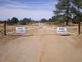
The road I was *supposed* to take to get close to the hash.
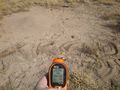
GPS coordinates and XKCD marker.

Me grinning and son being goofy.


Achievements
Redaragorn earned the Graticule Unlocked Achievement
|