2009-11-13 52 10
| Fri 13 Nov 2009 in 52,10: 52.1667914, 10.9201152 geohashing.info google osm bing/os kml crox |
Contents
[hide]Location
Location
In the Elm near Warberg, the actual place belongs to Schöningen.
It's the Elm forest, which is no more an Elm forest. Mostly it's beech now, but partly Elm has also been replaced by Pine.
Participants
Expedition
I was at Braunschweig for two days, and there was a strong urge to go hashing if possible and reasonable. Well, possible and reasonable are both very subjective in the context of geohashing, or even meaningless. This location was further away than I wanted to go, it was less accessible, I didn't have any kind of decent map, the weather was wetter, but still I couldn't convince myself not to go.
So, I actually started from Braunschweig in the late morning, went by train to Frettstedt and caught one of the few buses which go from there to Warberg. The bus was surprisingly full, but the fact that the only people on the bus older than about eleven years were the driver and me, clearly showed that it came from some primary school and went for the soly purpose to bring children back home from there. However, it was a public bus, came along not too far from the station and let me get on.
Left the bus at Warberg and found that compared to what I had estimated from a bad map without a scale before, the hash was about 1.5 the distance from the bus stop. However, there was supposed to be some semi-direct forest track, so it shouldn't be more than about two km to get there. It was constantly changing between light rain, not so light rain, and short periods of very light rain.
Reached the forest on a paved way, which continued as a gravel track. At the forest margin, there was a detailed map of the area, and I chose a route to go. However, there wasn't much to choose, since this was actually a forest of the not-so-much-developed kind - i.e. there was a rather poor track network. I found two possibly reasonable ways on the map, chose the shorter one, and went off into the forest.
It was easy to find the actual intersection where I had to turn left. It was less easy to convince oneself that what was there actually was the forest track shown on the map. However, being part of a longer hiking trail, it was kind of a way - an unpaved footpath, that is, and a very wet one as well. Still, it wasn't too bad, and it did bring me to another gravel track, which came quite close to the hash.
Coordinates reached, no reason to stay, now back to the village.
I wasn't very convinced by the way I had come here, so I decided to try the other variant which should be a bit longer but use somehow paved ways. Actually it did for some time, but at some point I noticed that I was going into an entirely wrong direction. Looking back, and walking back, I found the place where I should have turned left. There might have been a way, but if there was, it's been gone for decades. And since there was not really a chance to find another route, I walked back almost to the hash, basically failed on a try to use a shortcut, and finally was almost happy to be back on the path I had been coming on my way out. Hurried up, but it didn't help: I missed the bus I had believed was a secure thing by about five minutes.
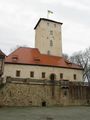
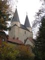
I was still kind of lucky that there was another bus only one hour later, but I was stranded for that hour. Time enough to explore the village, and primarily the castle, which is some kind of school nowadays.
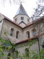
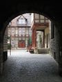
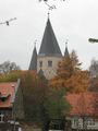
The next bus which went into some reasonably direction brought me to the small town of Königslutter. Königslutter is quite famous, mostly for a medieval monastery church which is referred as one of the most impressing romanesque buildings in Germany, with a good amount of art that looked very much worth seeing from the informations I had been able to gather. So I questioned the driver until he had to admit that there was a bus stop not far from the church, where I got off and walked over.
Only to find that the whole complex was closed off. Of all the time of the year, it was closed for two days to house some conference. So all I could do was to half-circle the church from the outside, take a few photos, and leave for the town centre and the station, slightly frustrated about that chain of bad luck.
Stupidity distance: 31 km. Actually it would have been reasonable to not start at all.
Gallery
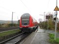
Wet railway station
Wet busstop. Get off here.
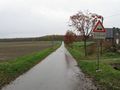
Wet road out of village

Natural and artificial clouds
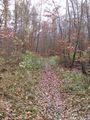
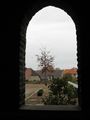
Wet path through the forest
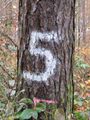
Five metres to the hash?
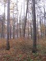
Wet hashpoint
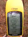
Coordinates reached
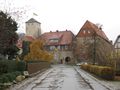
Castle Warberg impressions
Königslutter cathedral impressions
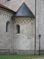

Behind that door it would get interesting...