2010-01-07 8 99
| Thu 7 Jan 2010 in 8,99: 8.1508984, 99.0999239 geohashing.info google osm bing/os kml crox |
Contents
[hide]The Place
Quite far east of Krabi, Thailand.
Who Went
- Felix Dance - by normal bike.
Expedition
Felix Dance
I spent the morning traveling from Phatulung, Thailand, by bus to Krabi in heavy rain. Having found myself a suitable hostel I had decided to spend the rest of the day going for a short walk and hanging out reading a book on the balcony.
Before all this, of course, I checked the internet for geohashes. There happened to be one quite close-by to Krabi, but I was feeling pretty exhausted so I didn't bother going for it... but I did enter the coordinates into my GPS.
As usually happens, about five minutes after I left the hostel I changed my mind and searched for a bike hire place. Hiring a bike for the precise time of three hours I headed off in the direction my GPS indicated. When my GPS had got a lock on the satellites I was horrified to discover it was actually over 20 kms away, seriously stretching my time limit, let alone daylight. Doubly so, knowing I'd be doing a lot of winding. In the end the route was 35 kms to the geohash. And since I didn't think I'd be going for it I didn't have any info on what route to take so I was traveling blind with only the arrow of my GPS to guide me.
This proved to be pretty nerve-wracking, as every time the road veered off by 90 degrees to my target I had no way of knowing if it would ever veer back again, or if a side-road would present itself.
I passed some pretty spectacular scenary, all the best from Krabi, with Droogs towering over the landscape like a scene from 'Avatar' - seemingly hanging in the air. I've got a photo of a couple below, but it doesn't really do them justice.
After an hour or so, I headed off the main road and onto a smaller road. Once this became uncomfortably orthogonal to my target I headed off this onto an even smaller road. After a while I was presented with a choice: north or south at a T-junction, with the geohash point lying dead ahead. I don't know why I chose north - I had to chose something - but it's a decision I rue with all my remaining energy to this very minute.
After waving sporadically to various bemused passers-by, I came to the road's closest approach to the geohash point: 2.5 kms. It was starting to get dark already but I pressed on into the roadside plantation regardless.
After a few hundred metres of low regrowth and dark canopies, I came to a creek. It doesn't look like much in the photo (in fact you can't even really see any water) but it was quite tough to cross, being steep on both sides. My sandalled feet got covered in bright red bull ants and I encountered a lot of garish yellow-coloured spiders.
On the other side I continued for another few hundred metres before I hit a wall: impenetrable jungle. Now I know what you're thinking: "Impenetrable jungle? I bet I could penetrate it". You couldn't - this stuff was serious. Thick with vines and small trees, crawling with insects and arachnids and getting steeper as it went further in, climbing a local droog (rocky hill with very steep sides). I gave it a go and determined that it would take me well over an hour to travel 500m - I was 1.41 kms from the hash.
I gave up, but didn't quite lose all hope. I spent the next half hour (to 5pm - they're an hour earlier here so it gets dark early) riding aimlessly along dirt tracks (lucky I'd got a proper mountain bike) looking for a way around. A few places looked promising, but all ended in jungle - it seems the plantations were just narrow forays into the forest. Eventually I gave up properly and rode home, avoiding the angry dogs and determined traffic.
The ride home was actually quite good - I got another head wind due to a wind change (typical) but was free from the tyranny of choice as to my route, and no longer needed to stress about turn-offs. I was also quite proud that I had done all that could be done for that hash - without knowing exactly where they are on Google Maps it really is hit and miss. I got the bike back half an hour late, but they didn't fine me. I was so exhausted I ate a whole loaf of bread in my hotel room and bought an ambitious 6 litres of water.
Once online I had a look at the route I should have chosen - here I discovered that had I headed south at that intersection I could have bypassed the jungle and achieved Thailand's first geohash. It's always very frustrating when one realised that - one looks at the time to see if one can return by midnight. 10:20pm - not a chance.
My route (same both ways) is linked here. Total ride: 70 kms.
Photos
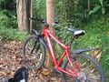
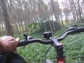
My bike at a creek
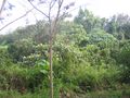
Impenetrable forest
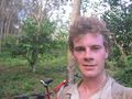
Felix near the geohash
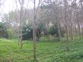
The Plantation
Riding off
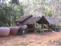
A forest hut
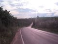
The road from near the hash
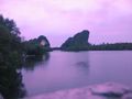
Droogs near Krabi


