2010-02-04 48 11
| Thu 4 Feb 2010 in München: 48.0291689, 11.6298693 geohashing.info google osm bing/os kml crox |
Location
Today's location is in a meadow near Taufkirchen, south of München.
Country: Germany; state: Bayern (Bavaria, EU:DE:BY); administrative region: Oberbayern; district: München rural district
Expedition
Danatar
On my way home from Verona, Italy, I took a very tiny (<0.7% of total distance) detour at the Autobahn interchange München south and left the Autobahn at the next exit. I parked the car next to a house (it might belong to a plant nursery) and walked across the partly snow-covered meadow straight to the hashpoint. Once there, I compared both my car gps and my new outdoor gps, found out that they differed by 0.00003 degrees, took pictures and returned back to the car for another 300 kms of Autobahn.
Danatar earned the Border geohash achievement
|
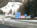
One border...
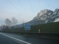
...and the other. Please note the high walls, minefields, checkpoints with guards and other fortifications. Erm... Yay for Europe!
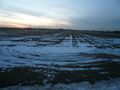
Straight ahead
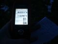
Coordinates reached!

Look who's back from hibernation


