2010-03-02 50 10
| Tue 2 Mar 2010 in Schweinfurt: 50.0468236, 10.0411442 geohashing.info google osm bing/os kml crox |
Location
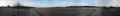
Today's location is on a field track next to a former waterworks between Wasserlosen-Schwemmelsbach and Wasserlosen-Kaisten.
Country: Germany; state: Bayern (Bavaria, EU:DE:BY); administrative region: Unterfranken; district: Schweinfurt rural district
Weather (7:30): fresh, but the sun was starting to rise
Expedition
Danatar
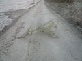
Sunrise is earlier day by day, so that on this before-work expedition I actually could see where I was going. Coming from home and following my written route instructions, I continued on the Autobahn A7 beyond my usual exit, took the exit Wasserlosen and circled around the hashpoint to Kaisten, then I drove a while on a small road towards the hashpoint. I left the car, walked the rest of the way to a fenced-in building which turned out to be a former waterworks according to the sign on the fence. I walked on the frost-covered track along the fence until everything looked like on Google satellite view, took the GPS out of my pocket and... hooray, only 4 metres off! A few steps to the left, front, back, right, and I was at the hashpoint. I then took some pictures, went back to the car, and drove to work.
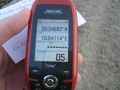
GPS

Coordinates reached. Including indirect sunlight!
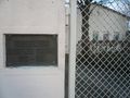
Kaisten waterworks, 1962 to 1964
You shall not pass! Yes, I shall... *kick*
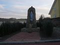
Statue of St. Mary at the town limit of Kaisten.


