2010-03-22 48 9
| Mon 22 Mar 2010 in 48,9: 48.6181632, 9.2557742 geohashing.info google osm bing/os kml crox |
Contents
[hide]Location
On the Kleinbergle, a little small mountain at Neckartailfingen.
At least that's what the name Kleinbergle means: klein = small, Berg = mountain, and, in the local dialect, the ending -le turns a word into its diminutive. So it's a double small mountain. Actually, its elevation is 90m above the neighbouring Neckar valley level.
Participants
Expedition
This hash was conveniently located on a reasonable bike route to Stuttgart, and even on a day where I actually wanted to go there for two events in the evening. What kept me from going was that my gear was defective, and I had failed obtaining the necessary spare parts. However, I found a temporary solution using available parts which would require to pack some additional tools to be able to readjust it if necessary, which I applied in the morning. After a seemingly successful test run I planned out the route, packed my stuff, and then found that, on the test run, some huge staple had managed to get around the kevlar layer in the tyre and punched the inner tyre. After that was repaired as well, and everything else that was urgent taken care of, I hoped it would be not too late - actually, it was much later than reasonable to start on that trip.
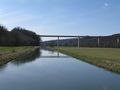
But I went anyway. Along the Neckar valley as on many trips before, to hash village: Neckartailfingen.
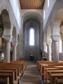
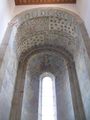
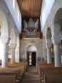
Neckartailfingen would be quite non-notable if it wasn't for the church of St. Martin. I have been peeking in there before, but I decided this time should be time enough to make at least a few photos. I will come back for a closer visit.
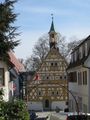
Built in the beginning 12th century in romanic style, according to recent research, its date of inauguration must actually have been 1111-11-11. Unlike most remaining churches of a similar style, this one is a rather small village church and not part of some large and wealthy monastery. They also found that some of the roof tiles and most roof beams are still original from those times, making it the oldest roof in southern Germany. Also preserved are a few medieval wall paintings. However, the churchtower is much newer (from the 16th century) and a very common style, but still notable in an entirely different context: Due to some instabilities in the ground, it's visibly inclined, hanging over notable 1.3 metres at one corner.
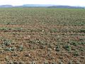
All this was only a few hundred metres from the hash. Getting up on the hill wasn't that easy, as the way was steep and in bad condition. At the top, I found... another UFO of the kind we already had found at Klasdorf. This time almost at the hash, even, which otherwise was, well - just another field. And some nice views in all directions.
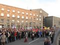
Down into the Aich valley, up into the Filder hills, and through all that madness of steady ups and downs, heavy road traffic, missing bike trails and mad car drivers that make the southern suburbs of Stuttgart, I finally reached the city just in time, only 15 minutes early for the weekly demonstration of people who still believe that democracy is a nice concept and politics shouldn't be about spending billions for a construction project that is not only useless but very much harmful even for what it is supposed to do.
Gallery
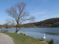
A few impressions along the Neckar valley

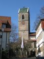
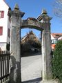
Church of Neckartailfingen, notable in several respects.
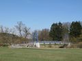
Two more impressions from hash village
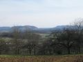
Panoramic view on the Albtrauf
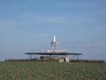
An UFO has landed - view from hash!
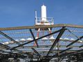
closeup
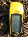
The hashpoint
Coordinates almost reached (not trampling crop)
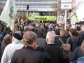
Final destination: Attending a weekly protest demonstration at Stuttgart


See also
Evangelische Martinskirche Neckartailfingen - page of the parish about the church, with more (and better) pictures (german only)