2010-03-31 -37 145
| Wed 31 Mar 2010 in -37,145: -37.5090957, 145.1379420 geohashing.info google osm bing/os kml crox |
Location
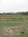
Whittlesea, close to the edge of a streambed
Participants
Plans
Roll on out first thing in the morning, get to the hashpoint, roll back on home. 46km on surface roads.
Expedition
Oh what a day for geohashing! I put in some mean hours yesterday, meaning I had a few hours to spare this morning, so decided on driving up to Whittlesea. It wasn't the most inspiring morning, with low cloud cover and mist all around, but twas a fun drive past the memories of several hashpoints along the way - right past the ill-fated point from 26th March, actually.
However, how's this for awesome: twas a blue moon in the sky this morning. Apparently this means it's the second moon this month. It was hanging in the sky, all gibbous and such. Awesome.
We got out to the access point to the hashsite with no problems - when I scouted the area on Google Maps, it looked like there was an access point that would take me right up to a few metres of the hashpoint (which is on private property). It took a couple of goes to find the entrance to the access point, but it was duly found and identical to the Google Earth scopage.
I walked the dog out along the access point to streambed, only to find my way blocked by the FENCE OF DEATH - a patchwork fence barring access to the streambed. Assume this is to stop the local kids riding their bikes around and tearing the place up and stuff.
There were rabbits EVERYWHERE, running all over the show like mad...rabbits. The dog - he's a terrier, a breed bred specifically to chase down small, fast-moving animals and kill them - was borderline unmanageable, so I took him back to the car and left him there while I went to do a bit more recon.
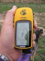
Nearly all the avenues to the dried streambed were blocked, but I did manage to finally find a path that lead down past a stand of pine trees and across the streambed to the opposite bank. I climbed the bank - note that the waterway still counts as public land, so I wasn't trespassing - grabbed onto a fencepost for stability, and looked at the Garmin, praying that I'd be within the circle of probability...
...TROUBLE TRACKING SATELLITES. NEED A CLEAR VIEW OF THE SKY....
...I waved it in front of me half-heartedly...
...then BINGO - 7 metres - within the COP! AWESOME! Trip justified!
I trduged back to the car to a less-than-enthusiastic reception from the dog - HOW DARE YOU EXCLUDE ME FROM CHASING RABBITS - and took him for a walk at the nearby parklands, where he contented himself by eating grass for five minutes.
The drive back was uneventful and it's ended up being a beautiful Autumn day today.
Tracklog
Photos
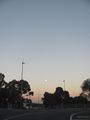
Blue Moon (really)
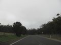
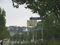
Sunrise drive
Close to hashpoint but dog going crazy
Hashpoint across the way
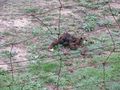
Horse dung. Fragrant.
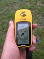
Coordinates reached!
Whittlesea - TOTH, anyone?
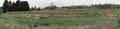
Hashpoint Pano
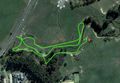
Route taken
.JPG)
.JPG)
.JPG)
.JPG)
.JPG)
.jpg)
.JPG)
.jpg)