2010-04-02 43 -79
| Fri 2 Apr 2010 in 43,-79: 43.8064218, -79.1217503 geohashing.info google osm bing/os kml crox |
Location
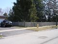
Today's location was behind a fence in Pickering in a community west of Frenchman's Bay.
Expedition
Splitdipless
It just so happened that I was planning on driving past Pickering today to visit my parents for the weekend, and also because I left a Waldorf Salad in the fridge at work in Pickering as well. So I hopped into 'Em,' my car, and drove to across the street from the point.
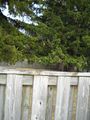
Satellite imagery suggested that the point would be by some trees, so I stopped my car when I got near some fairly big trees. Then I noticed the fence surrounding the property. I walked up and down the fence, sticking my GPS over the fence at points, but eventually found a point along the fence that was within the accuracy of the GPS for the point.
I took some pictures, but now that I'm at the parents place, I have no idea how to get them from my camera to their computer. (Also, I'm not used to typing in Qwerty, so sorry if there are any typing errors. I knew I should have brought my laptop.)
Pictures will have to wait until later.
Abhryll
An unseasonably-warm Good Friday (or GREAT Friday), today was the perfect day for a stroll by the lake shore. I took the GO train to Rouge Hill station and walked about 4km from there through Rouge Beach Park where there were lots of people, and geese, enjoying the beautiful day. The hashpoint itself was directly north of the beach in a residential area.
Photos
Splitdipless
That looks like an interesting obstacle.
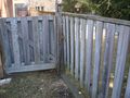
The little corner where I could get the point.
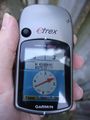
3/3 is success to me.

Grin. Never optional.


Abhryll
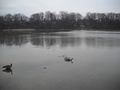
Geese!

11m away (just visible in the background - naked toes)
The fence


