2010-04-18 45 -123
| Sun 18 Apr 2010 in 45,-123: 45.8919619, -123.4373027 geohashing.info google osm bing/os kml crox |
Location
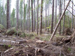
Near Jewell, Oregon. In a recently logged section of forest.
Participants
Plans
My original plan was to head to the hashpoint, and then head up north, but I didn't get started as early as I needed to do that.
Expedition
It looked like it was a few hundred feet from the road, but I wasn't sure if the road even allowed access.
As it turned out, the roads were all open. On my way in, I encountered someone who had been doing target practice in some rock quarry, but I explained what I was doing and he thought it seemed interesting, but not enough to say "I want to come along!".
I continued in, and the Rhonda's Mom(TM) trick of having the coordinates of each turn really helped. I found my way as close to the hashpoint as I could get on the road and then checked out ways into the hashpoint. I deferred from starting out over the logged section, and first went into a dry creekbed and through the forest, but eventually emerged into the logged section. There was a lot of "Large Woody Debris" left behind, and the going was slow.
The slope became quite steep, and I was worried as a stream seemed to be getting closer. However, I knew that Google Maps said the stream was quite far away from the hashpoint, and Google's always right(TM). I finally got close to the hashpoint, but there seemed be enough overhead interference that the GPS kept swinging around. I got the distance to below 10 meters and declared it a success.
I then had to scrabble back up the slope that I came down, which was a little easier, but not a much, since I ended up going a different way, which wasn't as easy. Then I had to make my way back to the road. I came in via the forested section, so I got to try to follow my track backwards in my GPS. I'd saved a few points as I went in, so that process appeared fairly easy.
However, I must have missed one of them, because the distance kept going up, and I was about to give up and backtrack some when I looked around and saw and opening in the trees, and the "marker" I left there.
As I was scouting along the road looking for the best way into the hashpoint, I noticed a pepsi bottle lying on the side of the road, so I figured I would geo-trash and bring it home. I didn't want to carry it to the hashpoint, so I left it in the pathway that I went in so I'd could pick it up on the way out. (It is a good thing I didn't with all the climbing on all fours I had to do at times,)
Lastly, on the way in, close to the hashpoint, I was having trouble climbing over all of the trees and such, and I finally grabbed a tree branch to use as a walking/climbing stick and it worked great. So, I'm bringing it home and to the next expedition. So it might be a hashcot, or maybe it's a Drag-Along, since I picked it up and dragged it along. :-)
I got back to the car, and took some more picture and headed homeward with my bottle and "hashcot".
Photos
Will follow when I can upload them.
Jim earned the Land geohash achievement
|
Jim earned the One with Nature Geohash Achievement
|
