2010-05-07 45 -120
| Fri 7 May 2010 in 45,-120: 45.7231920, -120.9970169 geohashing.info google osm bing/os kml crox |
Location
In a field next to Centerville Highway on the north side of the Columbia River.
Participants
Plans
We were on our way to an earlier-planned visit with friends across the river in Oregon, and considering the location of the roads and bridges, this geohash constituted a trivial detour. We had hoped for a Portland geohash on the Saturday to introduce our friends to the sport and have a chance of meeting some of the Portland/McMinnville crowd, but the algorithm didn't cooperate.
Expedition
From Vancouver we followed the I-5 south to just north of Seattle then connected up with the I-90 for a déjà-vu of our globalhash route towards Idaho. We turned south just after Ellensburg on highway 97 then, just as we were passing a giant field of windmills started officially geohashing as we detoured to "Centerville Highway." Discussion about whether we were passing a wind farm or an electricity farm would probably have continued all the way to the geohash, except that the GPS was doing something amusing. Centerville Highway wasn't really a highway, or even a single road. It was more like a designated route through the network of farm roads in the vicinity of the geohash. So as we followed Centerville Highway, the nuvi GPS receiver kept telling us to "turn left on Centerville Highway" or "turn right on Centerville Highway." Pavement markings made it clear wheich was the main road, and often the only other option than to follow it was to continue on --or even do an almost 180 turn onto--a dirt farm road.
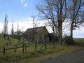
Then we reached Centerville itself. It was a classic over-the-top caricature of a middle-of-nowhere, almost-abandoned farm village. Dogs napped in front yards. Trucks and other farm equipment rusted peacefully on rotted tires. Doors on vacant buildings swung creakily in the wind. Faded signs designated the former functions of decrepit, weatherbeaten structures as General Store and Garage. We had reached the very centre of nowhere, and we continued beyond it.
Centreville Highway kept up its amusing behaviour. Many of the fields along the way had broken down fences with large gaps in them, and there were not a lot of crops planted, so we were optimistic for the geohash as the GPS receivers counted down to single digits. We parked on a Dead End road a couple of hundred metres past it (just in case someone else needed to drive on Centerville Highway while we were there), and walked slowly back. The geohash was clearly in a ploughed but seemingly unplanted field, 51 metres inside the fenceline, but said fence was well-maintained and continuous, so we did not enter the field.
Meanwhile the cattle in the field across the road were very interested in us, all lined up against the fence watching us, so we went over to talk to them. As we approached they backed away from the fence but maintained their curiosity. Robyn spent a while trying to persuade at least one of them to come back, using eloquent logic, seductive vocal tones and a very tasty flower as inducements, but didn't manage to lure one close enough to pet.
Dalles Mountain Road, the route we had chosen to continue to our destination, turned out to be unpaved, so it slowed us down quite a bit, but it was worth the drive. Every single place you could point a camera was a photo just waiting to be dropped into an essay on the history of the American farm. We could have spent a week driving along that road taking pictures of livestock, fences, outbuildings, machinery and rolling hills, but we wanted to see our friends so we kept rolling until we got back to the pavement and onto Hood River in time for dinner.
Photos
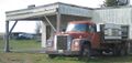
Downtown Centerville. A movie set dresser couldn't conceive of a more derelict town.
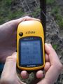
The further you are from the geohash, the better the GPS shot will turn out. It's pretty much guaranteed.
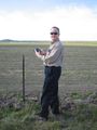
Wade posing in front of the geohash.
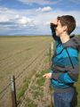
Robyn looking wistfully towards the geohash.
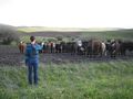
Robyn holding forth on the delicious qualities of this particular flower, to a rapt bovine audience.
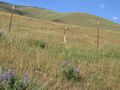
Only one of many photos of weathered barns, gnarly fallen trees and pastoral landscapes.
Which came first the fence or the leg? We have no idea whether a deer got hung up on the fence and predators dragged away all but the leg, or someone found a severed leg and hung it on the fence.


