2010-05-25 49 9
| Tue 25 May 2010 in Würzburg: 49.7487069, 9.8679466 geohashing.info google osm bing/os kml crox |
Location
Today's location is in the forest near Kist, near Würzburg. The spot is in the Guttenberger Wald part of the forest, but locals probably will say "in the Steinbachtal", the Steinbachtal being the valley at the northern edge of the forest.
Country: Germany; state: Bayern (Bavaria, EU:DE:BY); administrative region: Unterfranken; district: Würzburg rural district
Expedition
Danatar
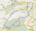
It is Towel Day! After missing the Tron achievement last week because of insufficient planning, I wanted to get it this time, so after thorough planning I set out on my bike light cycle. I crossed the railway on the "Grombühl-bridge", then I followed the "Ring-park" around the old city until I reached the Main, then followed it to a pedestrian/bike bridge. On the other side the Steinbachtal valley began, which I followed for a while, then I took a forest track which should have brought me near the hashpoint.
Should, because I took the wrong track, which curved slowly but surely to the south instead of going west. When I had followed it for 2.5 km I reached an intersection (see picture 1), which was conform with my plan. But when I looked at the map on my GPS to check, the "you are here" arrow was at the wrong place. Luckily, the map showed the forest tracks, so I continued in the direction of the hashpoint. Some of the lines on the map did not match with track, especially those I wanted to take. After a large detour and even cycling away from the hashpoint for a while, I finally reached the track I had wanted to take from the beginning. From there, it was only a matter of time until I was near the hashpoint.
I parked my bike light cycle on the forest track near the hashpoint and entered the underbrush between the trees, loaded with a towel, Scott with his towel, my camera, the note with the coordinates and my two GPS devices. GPS accuracy was bad and there were many dense bushes, so instead of going straight towards the hashpoint I zigzagged around the spot in a big circle before reaching it. I saw a first mouse, running along a long stick. Although it was difficult to proceed, I didn't panic, because 1) as I told before, I had TWO GPS units, so I wouldn't get lost; 2) it was Towel Day and I had a towel and 3) Scott was with me, and he also had a towel. My GPS units finally decided on a spot between trees (surprise...) with a little less undergrowth, where I took the usual pictures. The spot was only 8-10 metres from the track, so I took a shortcut through the bushes instead of going all the way back. When I reached my bike light cycle, I saw a second mouse, which vanished under a log.
I continued towards the west, where after a few hundred metres I saw a third mouse crossing the track in front of me. They all were late, Mouseover Day was three days ago... Not much later I reached the B27 federal road and followed it to Höchberg. After cycling through Höchberg, I soon reached the Main again, which I crossed at the Alte Mainbrücke. Not much later, I reached my home, very happy because of a successful expedition and the healthy exercise.
I cycled 13 + 13 = 26 km.
Danatar earned the Tron achievement
|
Danatar earned the Don't Panic! Achievement
|
Maibaum in Höchberg
bikelight cycle and statue of St. Kolonat on the Alte Mainbrücke, the Festung Marienberg in the background
Tracklog
http://www.everytrail.com/view_trip.php?trip_id=634678
I didn't log my home road for privacy reasons, but you can see on the map that the route can easily form a complete loop with any of the streets between the end and the start without crossing itself.


