2010-06-08 35 -80
| Tue 8 Jun 2010 in 35,-80: 35.0910764, -80.9577309 geohashing.info google osm bing/os kml crox |
Location
Near the North Carolina, South Carolina border. It looks to be only a few hundred meters from a previous geohash.
Participants
- Art may attend depending on when he can get out of work.
- Rhonda will try to not get lost in the 10km straight line distance from her hotel.
Plans
Art plans to park in the visitor lot at the nearby electronics company and hike to the hashpoint.
Expedition
Art
Rhonda
After eating dinner at my hotel, I set off with hand-copied google maps instructions, a programmed GPS, a water bottle, and Sophie. Once the GPS figured out where it was, I found out I was 10.1 km from the geohash. I'm not sure, but I think that's the closest geohash to where I was staying that I've ever had.
The first part of the instructions were exceptionally easy, as I had driven them to the work site every day for the last week. I drove past the reason I'm in NC and waved at the very large sign at the site driveway, then drove past some of the restaurants I've had lunch at last week, and then drove right past my turnoff. You'd think that because the left turn I had to make was right where I had lunch not once but twice, I'd manage to catch it.
Of course, I didn't realize I had missed it until I started seeing signs for the 485. I knew for sure I wasn't taking, or even crossing, the 485. Of course, by the time I had processed this thought, I had missed the last turn before the highway. I managed to cross without entering, turned into a gas station, got myself going in the opposite direction, and found my turnoff without too much more fuss. As much as I tell myself I don't need a car GPS, one thing written instructions can't do is "...recalculating..."
Nah, I still don't need a car GPS. I know how to turn around. I was, however, definitely going to be late.
There was road construction of course, and one of the roads I was supposed to make a right on either didn't exist or was so poorly signed that I couldn't see it. I did eventually find the next road I was supposed to take, mostly by following signs for 77, which I knew I did have to cross.
I saw roller coasters as soon as I crossed the state line. I wonder if I can get my work finished early enough to stop by there before catching a plane back...
Finding the correct road turned out to be more difficult than it should have been, and I probably annoyed some locals with my slow approaches to green lights then sudden swerves into the left turn bays at the last minute. South Carolina, here's a tip: put a sign naming the cross road somewhere where it's legible before the driver reaches the intersection. Thank you.
My GPS was pointing directly to the right as I approached the parking lot turnoff. In the corner closest to the geohash sat a car. There were a half dozen other cars scattered randomly around the lot, but the odds of a lone car being in that exact spot not being a fellow geohasher were slim. I parked right next to it and prepared to set off.
A few steps across the neatly mown grass, and I saw somebody walking across the grass from the forest toward the parking lot.
"Hi," he said. "Are you from the internet?"
Together

Art had already been to the hashpoint and was returning, but willingly joined Rhonda for a second trip. The underbrush wasn't so bad, he said, and there were a couple of trails. Animal trails, not the wide kind that humans make.
We walked across the mown lawn, then the unmown grass, saw some deer prints in the mud at the edge of the forest, then followed what was probably a deer trail into the trees. We twisted and turned, joining trails as we found them if they were going our way for a time. We squished across a very small creek, which Art said was definitely not the creek shown on google map view.
And then, in a small clearing, we arrived. Art had placed a marker, which Sophie immediately went to check out, as she had only ever seen the twigs and pinecones sort of marker before. It was a geohashing business card!
A little bit of exploring ensued, and the creek shown on google maps proved to be wide, murky, and of unknown depth. We were glad it wasn't between us and the hashpoint.
Then we walked back out of the forest, following a different route, and back to our cars.
Photos
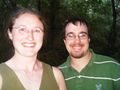
Proof that we were in the same place at the same time
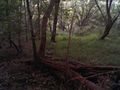
at this place in the woods

