2010-06-12 47 -122
| Sat 12 Jun 2010 in 47,-122: 47.8070820, -122.1346896 geohashing.info google osm bing/os kml crox |
Location
A large wooded lot in south Snohomish County somewhere between Route 9 and Maltby, with a massive population of stinging nettles
Participants
Expedition
OtherJack
So the hashpoint was on apparently unused woodland, not far from a road, about 15 miles from my house, and, it was forecast to be Seattle's warmest day so far this spring, sunny with a whopping 74 degree Fahrenheit high! Sounds like a great day for a bicycle geohash, I thought to myself. As I packed my backpack, it occured to me that I might want to bring some heavy clothes, in case the bushwhacking got tough. But more optimistic thoughts prevailed, and unfortunately I ended up setting out bearing a light pack, wearing shorts and a T-shirt. This was a Bad Decision.
After swinging by my workplace to retrieve a misplaced item, I set off on the Burke-Gilman. An hour and a half of glorious northeastward cycling later, I arrived at the small dead-end road that led toward the hashpoint, to find that it was labeled "Private Road." This was the first bad omen...
I cycled on up the private road, wondering if there would be a way into the unused lot behind its dead end, where the hashpoint lay. The answer turned out to be negative--the road ended at a large fenced farm property, with thick undergrowth blocking the way around it. However, I could see a clearing just off to the right that I figured must correspond to the next little road over. So there was still hope.
I wheeled out of the first private road, along the highway and then up the next one. This one was lined on both sides by houses and yards, and ended in a cul-de-sac. Much better prospects for getting into the woods--this was good. I was standing near the end of the road, looking around and contemplating my options, when a really nice old couple drove by, heading to their house at road's end. I asked if they knew a good way to get into those woods over there... when the lady wondered why, I lied that I was trying to find a geocache, since I figured she might have actually heard of that. It worked--she went "Oh, you're going on one of those trek things!" and told me about a little trail starting from the back of her neighbors' yard, that they used for mountain biking. According to her description, it went directly toward the hashpoint! Excellent! She even told me I could keep my bike at their place, and that if the neighbors saw me and asked why I was on their property, I could tell them she said it was OK. I gave her a big thanks.
So, optimistic again, I set my bike down against the couple's house, and walked unmolested across the neighbors' yard to the start of the trail, where I entered the coordinates into the GPS. I was about 500 yards south-southwest of the hashpoint--not bad, but still farther than I would have been had the first approach worked. But the trail looked good, so I set off into the woods.
I was about a third of the way there when I felt a small but sharp pain against my shins. I looked down... stinging nettles! Agh! Why didn't I bring those jeans? The nettles weren't actually that thick, so I was able to step over/around them and move on. A few dozen yards later, there was an even thicker colony of nettles growing across the trail, but I resolved to get through them, and managed to do so without a ton of pain. This went on a few more times, until finally the hashpoint lay less than 40 feet to my left off the trail according to the GPS, about halfway between me and the first farm's horse pasture. I could see the hashpoint with my own eyes.
But those 40 feet were absolutely overgrown with nothin' but nettles. If I'd only brought those heavy clothes, this would have been a cinch of a hash. Instead, though, it was going to be a very painful one.
I saw what looked like maybe an area with less undergrowth ahead, and thought I could reach it and then wrap back around to the hashpoint. So I picked my way through yet more poorly maintained, nettle-infested trail, and then tried to climb off-trail through a rare area of fern growth to where I could get a better view of the supposed clearer area. Unfortunately, said view informed me that said area was just as nettle-tastic as everywhere else.
Darn.
Reluctantly, I stumbled back down to the trail and walked back to the neighbors' yard, swearing to bring appropriate clothing on all future woodland geohashes.
The ride back was notable only in that I saw a pair of ducks doing the deed in public, right by the side of the Burke around 110th.
Photos
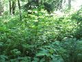
40 feet away... through this.
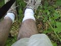
I was not prepared.

