2010-07-08 40 -89
| Thu 8 Jul 2010 in 40,-89: 40.7129432, -89.2686770 geohashing.info google osm bing/os kml crox |
Location
Next to Eureka College's Cerf Center in Eureka, Illinois
Participants
- Dvdllr & Rachel
Plans
Planning for this geohash was typical for the expeditions I undertake: bringing a mini flag, camera, GPS, and a paper flyer in case anyone wonders what I'm doing. Because the hashpoint was on a college campus, I had the unique opportunity to use its website to find a map of where I'm going, and identify the buildings before setting out. My destination was next to the Donald B. Cerf student center building. I learned from the website that this building contained a small Ronald Reagan museum (Eureka's most famous alumnus), which closes at 4:00pm during the summer. I thought it would be great to visit since I'd be there anyway, though that meant I'd have to leave work early (isn't that one of the warning signs of addiction?)
Expedition
So, I did leave work early, and on my way home I phoned my wife to have the needed supplies ready to go when I got home. After a quick change out of my work clothes, we both headed out and made our way to Eureka, which is maybe 25 minutes or so from Morton. We arrived at the college campus about 3:40. We entered the building and wandered for a little bit, since we'd never been there and weren't exactly sure where the museum was. The museum was one room, full of cabinets and displays of Reagan paraphernalia from when he was a student, and beyond into his presidency. There were a couple of other people in there, watching videos from the 1984 campaign against Walter Mondale. We didn't spend a huge amount of time in there, and so we went outside again and looked for where the hashpoint was. The satellite maps gave a pretty good indication of where to go, so I went to the spot and turned on the GPS to verify. I was almost exactly on top of it from just looking at the map printout, so a pretty good estimation! I've said it before, but I continue to be frustrated by the inaccuracy of the Garmin Nüvi. Granted, it's for automobile navigation, not geohashing, but it's irksome when I'm standing completely still, and my coordinates are jumping around as the Nüvi refreshes. I did at two times have both latitude and longitude accurate to the 10,000ths place, but it was very bright and sunny, and I had great difficulty getting the camera to focus on the screen when I needed it to. Regardless, I planted a flag in the general vicinity, with the website address printed on it (if you've found it and are visiting, "Hi!")
I kind of wanted to keep exploring the campus, and the rest of the town, but my wife wanted to go home again (she's kind of like a hobbit: never goes on adventures or does anything unexpected, yet still endearing). Thus ended the expedition.
Photos
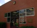
Entrance to the Cerf Center
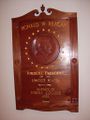
In the main man's museum
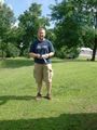
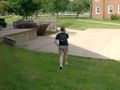
Standing on the hashpoint
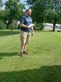
Flag raising
Rachel
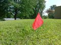
The flag
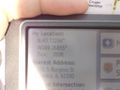
Proof of location (please see metadata for date & time)
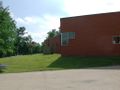
Location, relative to the Cerf Center
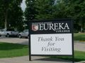
You're welcome!


Achievements
Dvdllr earned the Land geohash achievement
|
Dvdllr issued a challenge for the Tale of Two Hashes achievement
|