2010-07-08 59 11
| Thu 8 Jul 2010 in Sarpsborg: 59.9757611, 11.1099371 geohashing.info google osm bing/os kml crox |
Location

Destination is in a field right by the end of Flaenveien, in the area of Skedsmo, East of Oslo, which should be legally accessible for the public.
Plans
Closest public transportation is Leirsund train station, and the plan is to run from there and back, around 3 km following roads. I (W) will drag along a friend, and the preliminary schedule starts at Oslo S just before five pm, arriving at the destination some time after half past five, all local time.
Participants
Expedition
W
Me and eiggen have been looking to run together for a while, as we've both entered the half-Marathon distance at Oslo Marathon at end of September, and are training on our separate sides of Oslo. I've also been intrigued by the geohashing concept ever since the xkcd comic, but never had a portable GPS device, until I recently bought a HTC Desire. A few days ago I started checking coordinates for feasibility (criteria being something like not having to walk/run more than 10km, and not needing a car.)
After a few days of poor geohash targets, Wednesday's stock market opening gave me a perfect target in the North-West corner of the graticule bordering mine to the East. I checked out the maps, and as a train station was approximately (eyeballing it on the map) 3km from the target, SMSed eiggen and wondered if he'd be up for running at the location. After a few mails, including a link to the main page of the geohashing wiki, he was sold, and we agreed on a time and place to meet.
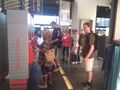
Taking the bus to the meeting place, I barely remembered photographing the bus and me in it, for proof of the public transport achievement. An electronic monthly ticket would not really prove anything!
Meeting up and getting on the train together was uneventful, we got to our designated starting point, and started running. The weather forecast I'd checked said 90% chance of precipitation for the area, but the few drops we felt around the starting point would prove to be all of it.
It was perfect weather for running. Probably below 20 degrees Celcius, but not by much, and overcast so the sun didn't kill us. Some of the uphill sections were a bit too tough for me (eiggen seemed to cope easily), and I had to slow to a walk until reaching a local maxima. The target was 97 meters higher than the starting point, with a total climb of 123 meters.
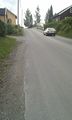
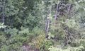
The final road to the target was signed and easy to find. As we approached the target, we found a sign declaring a firing range was at the end of the road, and to look for a red flag for when the range was in use. But I knew from the map that the range was on the opposite side of the road of the target, and no red flag was apparent, so we continued looking for the field I had seen on the aerial photo. As suspected, the photo must have been about ten years out of date, for in the meanwhile, a thick deciduous forest had grown up where it should have been. So we charged in, paying close attention to our map applications.
Not close enough I guess, because when the flag was to the left of the green dot, I claimed we should go East. When that didn't get the two closer together, I remembered that the flag was the target, and we'd walked in the wrong direction... Back we went, and fighting off very hungry mosquitoes, we finally got the two to intersect as well as we could. The accuracy of the GPS was a bit lacking, but I decided the nearest evergreen was the target, and photographing commenced. I even got a shot of a mosquito, though I really wanted a shot with two or three feeding off of me at the same time, as they sometimes did. No marker was placed, as neither of us though to bring one.
With the slight detour in the forest, the GPS app claimed the route was 4.46km long. Running back, downhill, felt much easier, and we maintained a good speed to the train station.
Checklist for next expedition:
- Find better GPS app
- Bring water (eiggen brought enough for both of us, but if he hadn't, I would have been one thirsty geohasher)
- Bring bug spray!
Photos

W arrives at Oslo Sentralstasjon
W buying his train ticket
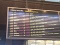
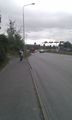
We took the train to Dal, 16:57, stopping at Leirsund
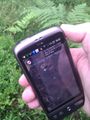
Arrived at the hashpoint
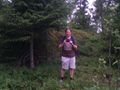
W standing on the hashpoint

Mosquito bites on W's leg
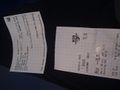
eiggen's train tickets
Oh, quick, gotta take a picture of the bus!

W on the bus to meet eiggen

eiggen at the train station

eiggen all packed and ready to run
Uphill uphill and then more uphill...
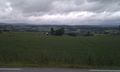
But at least the view at the top was nice!
Not the clear cut field I was hoping for...
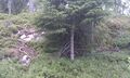
Lets say this tree is the target. It is as close as we can figure.
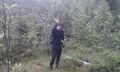
eiggen at the target, waving at the mosquitoes

Mosquito feeding off W's leg
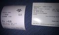
W's train tickets


Achievements
W's Achievements
W earned the Drag-along achievement
|
W earned the Land geohash achievement
|
W earned the Public transport geohash achievement
|
eiggen's Achievements
eiggen earned the Land geohash achievement
|
eiggen earned the Public transport geohash achievement
|