2010-07-15 39 -76
| Thu 15 Jul 2010 in 39,-76: 39.9697431, -76.6250946 geohashing.info google osm bing/os kml crox |
Location
Just off a road in a field, southeast of York PA.
I checked after work, and thought, holy crap, that's close to York. Then I zoomed in, and thought, holy crap, that's close to East York. Then I zoomed in some more, and thought, well, it's less than 3 miles from where I'm staying. How can I not try?
Participants
Plans
Program GPS, get on bike, go. Oh wait, eat a snack first because it's dinnertime. Then go. Have dinner after.
Expedition
Eat a snack. Put a granola bar in my geohashing bag, along with Sophie, chalk, and the GPS. Go to get bike. Realize bike has neither a bag nor a place to attach a bag. Put geohashing bag by the front door and open the door so it's easy to get the bike outside. Go back upstairs to get bike. Realize that front wheel is wobbly. Tighten nuts with pliers attachment on leatherman. Decide that leatherman would be a good addition to the geohashing bag.

Carry bike across living room, down stairs, and out open door. Get GPS out of geohashing bag and bring it back upstairs to program it. Tie geohashing bag to cross bar, lock front door, and set out. Forget written directions, bike helmet, and the balcony door.
I realized, upon reaching Market St., that I had forgotten the directions. Oh well; it was Left onto Market, first right, first left, then I could probably just follow the arrow.
I crossed Market St. to get on the right shoulder, and thought the street name directly across looked suspiciously familiar - despite not being named the same as the street I had just left, and I had never looked at it. First right, first right... I saw lots of business driveways, but no streets. There also appeared to be a creek or other type of greenway preserve, and none of the driveways seemed to get through it. I kept going. Eventually I saw a street sign with a name I remembered from my written directions. I guess google maps zig-zagged me through a shortcut, again, and I missed it, again. I turned right, and followed the road, happy to see the arrow pointing in front of me instead of to the side.
I recognized the name of my next turn, and the one after that. It was my last turn, too - or at least my last intersection. The road was winding, there were small hills, it was a very pretty rural road with no shoulders, and I passed a copy shop that had a bell tower. Wait, what?

I rounded a corner with 35m to go, and a lovely mowed grassy patch opened up beside a driveway. Sadly, this was not the geohash. On the other side of the driveway, where the GPS needle was stubbornly pointing with under 30m to go, was a line of trees with underbrush. I rode along the road, the GPS swinging to point beside me as it counted down to about 25m, then counting back up again. Just ahead was a break in the trees, so I stopped my bike there and assessed the situation.
It was a clearing, but a very overgrown one. No trees; lots of grasses, thorns, wildflowers, wildflowers with thorns, and either raspberry or blackberry canes with lots of thorns starting to encroach. As there was no shoulder, I wheeled my bike into the grass ahead of me to get it off the road. The grasses came up to the hub of the wheel as soon as I pushed it past the gravel edge. Maybe the land didn't go up quite as steeply as I had thought...
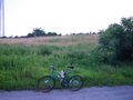
Lacking anything to lock the bike to, I simply locked the front wheel to the frame so it couldn't be ridden away, then lay it down in the tall grass just off the road.
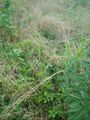
Then, cautiously, I pushed the grasses aside with my foot, trying to find the ground underneath. A few very slow steps and I was past the trees, so I turned toward the geohash. Some of the raspberry canes were up to my shoulder, but they were fortunately not very thick. They were thick enough to hide a nest of raptors though! They attacked en masse, but I managed to fend most of them off with my geohashing bag.
Because I was moving slowly enough that my GPS "go this way" arrow was unreliable, I was just watching for decreasing numbers. Bushwhacking, but with good visibility. Neat.

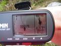
A few more steps, and I saw a very clear trail through the long grass, where it had been trampled. It headed forward and to the left, and I decided to follow it until the numbers stopped decreasing. They kept decreasing right down to just over 3m. Interesting... I moved another step forward, and my GPS briefly showed a number below 1m.
Sophie was too scared of a repeat raptor attack, or maybe she was still motion sick from my swinging the bag around while defending from raptors - either way, she declined to get out at the hash point. I tried out my new camera's panorama feature, and took three panoramas of three exposures each to make a full 360.
Then I followed the trail back toward the road, wondering if the previous person through the geohash had found a better way in. Where my trail joined the other one, I saw that the other trail led straight to a small break in the trees which looked even thicker than what my trail went through. So I braved the raptors again, and went around the trees instead of through them.
As I came in sight of the road, a vehicle was just pulling to the end of the driveway opposite where I left my bike. It stopped, and sat there for a little while, then the driver opened his window and said, "are you having fun?" I gave him a thumbs up and a grin, but didn't think to get my camera up until he drove away.

Sophie wanted to be in at least one picture, so I chalked the road at the closest approach, with a distance and an arrow added, then packed up to head back "home", the apartment in East York I'm staying in for 3 weeks.
On my way back, I saw a sign welcoming me to Springettsbury which I hadn't seen on the way to the hash. So that's where I was. Or rather, just outside of. Then I saw a street name that I recognized from my directions and which I hadn't taken, so I turned there and followed it back. Unfortunately, it had the steepest hill yet. Small by Vancouver standards, but I suddenly realized again how inefficient it is to pedal a bike on a road when it has big fat knobby tires that run a bit squishy. Maybe I should find a gas station with a tire pressure gauge and fill them up properly.
I found my way back and carried my bike up the stairs, saw that the balcony door was open, cringed at how much the air conditioner must have been overworking, and put my bike outside. It was just getting to dusk, when you don't really need extra lights to see by yourself, but you put the lights on so other people can see you.
Photos
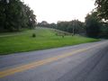
Too bad the point wasn't here;
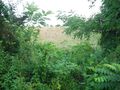
It's in there instead.
Let's go around those trees.
There's a trail!
Made it!
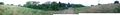
This is what it looks like.
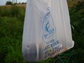
Fending off raptors -
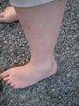
but they got me anyway.
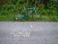
Displaced chalk markings.
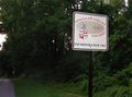
Welcome (back) to Springettsbury!


Achievements
Rhonda earned the Velociraptor Geohash Achievement
|