2010-07-16 39 -105
| Fri 16 Jul 2010 in 39,-105: 39.5731138, -105.1707132 geohashing.info google osm bing/os kml crox |
Location
Ken Caryl Ranch, just off C-470.
Plans
The dogs and I are headed for a morning hike.
Participants
Ralph, Tanna and Hendrix
Expedition
A fifteen mile highway drive took us to Ken Caryl Ranch, a neighborhood located in a pretty cool valley between the hogback just SW of Denver and the foothills beyond it. The hogback is a huge bunch of flat pieces of rock that were pushed up when the Rocky Mountains formed, which presently lie at a tilt, often allowing you to see the seemingly diagonal stratifications in them. Up near Boulder, this forms the [Flat Irons], and a few miles to the north of the hash itself is [Dinosaur Ridge], where the upheaval revealed several sets of fossilized dinosaur footprints. Last time I was up there I didn't see any velociraptor tracks, but they were probably just too sneaky to leave any trace behind.
Geology and paleontology aside, the hike was pretty nice. One hundred yards up a trail and then two hundred yards of relatively easy but somewhat thorny bushwhacking led us to the hash. The beautiful day and next ridge then beckoned us, so we headed up the hill towards the pass. Half an hour later, we almost got to the top, but then we didn't. The dogs had been doing some great scrambling, but the crux of the climb was a little too vertical for them. After hanging out in the shade by the stream for a bit, we headed back down to the car and home.
Photos
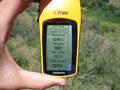
At the hash. Not sure why I couldn't figure this out on my first expedition.
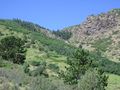
Looking up towards the foothills.
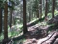
Lovely trail up towards the pass.


