2010-07-26 37 -110
| Mon 26 Jul 2010 in 37,-110: 37.6268164, -110.0344625 geohashing.info google osm bing/os kml crox |
Location
On top of a narrow mesa south of Deer Flat, overlooking Natural Bridges National Monument
Participants
- redaragorn and 3-yr-old son
Plans
We woke up that morning in Hanksville and I got the coordinates for the day with my phone. I plugged them into my mapping software and found a couple of hashes that looked *possible* given the route we were taking to get home. We would be going right by Natural Bridges, but I wasn't sure what the state of the dirt roads would be out to the mesa top, and I knew there was no way I was going to get over the canyon and up the mesa from the park. SO, I figured we *might* get there, but I wasn't super sure about it. And I knew we needed to get home at a decent hour so my wife wouldn't put up with me taking TOO long to do it. I figured we'd just have to see what it looked like when we got there.
Expedition
The drive south from Hanksville went smoothly and fairly quickly. It's always awe inspiring to drive down the canyon and over the Colorado River at Hite crossing. Whatever you may think about damming Glen Canyon and flooding the beautiful red rock, it is still amazing to see so much water in the desert. When we got near Natural Bridges, the boy had fallen asleep again, and we were making good time, so we decided to try our luck on the dirt roads and see how they were. They were actually much more passable than I expected. Although there were a few sticky spots, none made me extremely nervous (except maybe seeing the steep dropoffs as we were crawling up the side of the big mesa). Once we got on top of the mesa, it was pretty straightforward to drive as far south as we were able, then pull off and walk the 1/4 mile or so to the hash. The wife stayed on the road with the little guy, but I brought the 3 yr old with me to the hash point. He gets a real kick out of trying to find the red dot on the map with me--a true young geohasher in training. This terrain was a little easier than the day before. It was still sandy, but it was grassier with a light pinon-juniper forest. We found the hash with little difficulty and headed back to the car. Mission accomplished. On to the trip home...
Track
Track located here.
Pictures
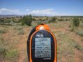
GPS coordinates
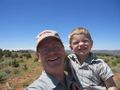
Me and the boy grinning
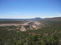
A look down at the canyons


Achievements
redaragorn earned the Graticule Unlocked Achievement
|