2010-08-09 27 84
| Mon 9 Aug 2010 in 27,84: 27.8145734, 84.8604294 geohashing.info google osm bing/os kml crox |
Contents
[hide]The Place
60 kms to the west of Kathmandu, Nepal, 100 kms to the north of Bīrganj, Nepal
Who Went
- Felix Dance - by mountain bike.
Expedition
Felix Dance
I'd been a bit peeved that after a week in Kathmandu proper, there would be absolutely no attainable geohashes, so when I saw Monday's one 60kms west of the city I jumped on it as good enough (it was across the major Marsyangi River, but the satellite image showed a footbridge nearby).
The Flat
I had planned to start at 6am to give me enough time to travel the 120kms to the hash and back before the monsoonal rains began in the evening. Unfortunately, the monsoonal rains had already started by then, so I had to wait until 10am before it was dry enough to get on my bike (when it rains here it REALLY rains). Unfortunately, again, my rear tyre was flat, costing valuable minutes repairing it.
The Ride
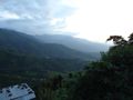
But soon I was on my way. After the nutcase hard slog up out of the Kathmandu Valley, I soon found myself with spectacular views of the next valley - and about two hours of solid downhill cycling (fun!) - at one point it occurred to me that I'll have to climb back out of this thing at some stage, but quickly dismissed it as being in 'The Future'.
But man, it was HOT. Really really hot. I was sweating like crazy and had to reapply suncream every 20 minutes. I'm not looking forward to the weather when I take my bike onto the Gangetic Plains - it's hot here at 1500m altitude.
The Crash
After a couple of hours of this sweaty work I was coming down a steep hill (actually, the whole ride was steep hills) when I saw a can rolling across the road. Being the destructive person I am I went for my usual 'can-ram', but forgot about my newly installed front mud-guard. This caught the can, stopped my front wheel as it got jammed in the mud guard, and flipped my entire bike over my head, depositing me on the asphalt. A Nepalese guy living just across the road ran to my aid, but luckily I only had a graze on my right knee (the scar there seems to grow by the month).
This Nepalese guy spent about 20 seconds sticking a bandaid on my graze without washing it or removing the gravel, but I was too touched by his kindness to reproach him for his pathetic effort. When he demanded Rps 100 for his efforts (probably his daily wage) I was so annoyed it put me in a bad mood for the rest of the day - the 'kindness of strangers' indeed. Thinking back to his reaction to the crash, I can see the dollar signs light up in his eyes. I shouldn't have given him anything.
Re-Position
But I left him behind to complete the last 15 kms to the hash. After about 40 minutes I checked my GPS again - overshot. By 7 kms. Hmmm... On closer inspection, after back-tracking 5 kms, it turned out the coordinates I'd transcribed were pure fantasy, and I had no way of getting the real ones. Miraculously, at that instant I noticed an internet cafe just across the road. I had to wait for an hour while the load shedding schedule allowed me to access the net, and I'd basically resigned myself to returning home unsatisfied. But as it happened, I was only 2kms from the hash!
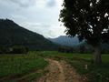
I ran out of the internet cafe, jumped on my bike and headed down the valley, through a small village (pictured) and across the rickety footbridge (also pictured) to the farmland on the other side. Stunned looks accompanied me everywhere, which I'm used to having done a fair amount of geohashing in third-world countries.
Total Failure
I was following a road that nicely headed right towards the hash, through streams and around mud huts, dodging water buffalo and goat herds, until I was only 500m away and the path turned hard left. In front of me was a steep valley, dense forest, and a high ridge that I just knew was impassable. The satellite image at the internet cafe told me the hash was on the other side - I hadn't considered exactly how steep it would be. It was already 4pm and getting afternoony so I decided to throw in the towel. I was totally exhausted from the arduous ride (skipping lunch hadn't helped either).
Bussing It Home
Getting back to the road I was planning to get to the nearest village and spend the night - the 65km climb back to Kathmandu (without lights) did not appeal to me one bit, and the horizon was dark with storm clouds. But luckily I flagged down a bus that offered to take me and my bike for a few rupees. I was back in my hotel by 9pm.
Here is my cycling route.
Estimated total ride: 70 kms
Closest approach: 4pm
Total time for geohash: about 9 hours.
Photos
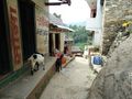
Village near the hash
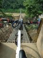
Crossing the bridge
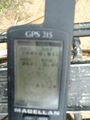
GPS
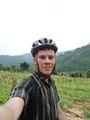
Felix 500m from the hash
Valley beneath the hash
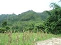
Geohash ridge
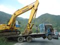
Excavator floating
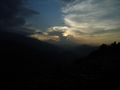
Sunset from the pass
Road to the hash

Bus buddy


