2010-09-11 40 -89
| Sat 11 Sep 2010 in 40,-89: 40.9314646, -89.4966417 geohashing.info google osm bing/os kml crox |
Location
Rural roads near Chillicothe's eponymous Recreational Area
Participants
Plans
My Saturday was rife with places to be at certain times, and hitting up the day's geohash worked out great. Chillicothe is a town on the Illinois River about 40 minutes north of Peoria, so getting there at 4:00 was convenient as I had somewhere to be at 5:00 back in Peoria. That's about all the planning there was: intent to arrive around 4:00 and spend about 20 minutes there.
Expedition
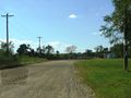
I was able to head out to Chillicothe a little earlier than I'd expected, so I got there about quarter to four. This wasn't the first time I'd looked at the satellite views of a location and been baffled by what I saw, so I was happy to use this opportunity to learn about the area. If you look at the Google maps, the hashpoint is right on the intersection of Benedict Street and "Unknown Road". This whole area around these lakes is full of roads unknown (and clearly are very wrong from what actual roads are there). I saw a bit to the east there was a label for Chillicothe Recreational Area, and I figured that the little rows of white rectangles were probably RVs. I arrived in the area coming up from Benedict Street, and I stayed on it to do a loop around before stopping at the hashpoint. I came into the entrance to the Rec Area from the north on Route 29, and did some driving around the place to see what the primitive camping sites looked like. The GPS was also confused as to exactly where the roads in this place were, since it couldn't figure out which road I was on and kept correcting itself. I don't blame Google or Garmin for being confused, since these little labyrinthine roads went all over the place: some ending in a barricade for unknown reasons, some snaking terrifyingly close to the lakes, and so on.
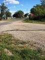
After finding my way back out, I drove back to the intersection where the hashpoint was. "Unknown Road" westbound turned out to be a driveway for a gravel company, so I stopped the car on the side of said driveway just before the entrance sign, so I'd be out of the way of any traffic. (Only three cars ended up coming by, and two actually went went down the driveway path, the occupants making sure to give me a good staredown as they passed.) I found the hashpoint itself to be slightly into the road, so I planted my flag a bit off so I could put it in the grass. I was done there, so I did a u-turn and headed back out of town.
Photos
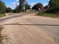
The intersection of the hashpoint.
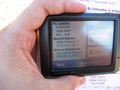
Got it.
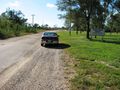
The car, viewed from the hashpoint. This is "Unknown Road".
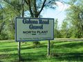
A closer view of that sign (which I didn't go past)
What's down there?
Victory flag

Geohasher


Achievements
Dvdllr earned the Land geohash achievement
|
Dvdllr issued a challenge for the Tale of Two Hashes achievement
|