2010-09-23 24 79
| Thu 23 Sep 2010 in 24,79: 24.8835011, 79.8916998 geohashing.info google osm bing/os kml crox |
Contents
[hide]The Place
4.5 kms to the north of Khajuraho, in the Chhatarpur, India graticule.
Who Went
- Felix Dance - by mountain bike.
Expedition
Felix Dance
What an easy geohash! Last night I went online to post my blog (sorry, shameless plug) and did my usual geohash location checking for the next day. I double-took - surely there must be a mistake! The arrow was pointing right where I was, at the temple town of Khajuraho on my cycle tour through India.
But no, on closer inspection it turned out be neither a mistake, nor was the point at the exact location of my current being, but 4.5kms to the north. The second amazing thing I noticed was that it was also basically on my planned route from Khajuraho to Chhatarpur, which also happened to be an easy 45 km day leaving plenty of time for geohashing. I must have executed some good geohashing karma recently! I was so excited by the prospect of deflowering two adjacent Indian graticules I couldn't get to sleep until 1a.m. (yes, I probably need a girlfriend).
Getting up in the morning to breakfast, clean my bike and check out of my hotel I embarked on the arduous 5 km trip to the geohash. Through a cute village, Rajnagar by name, I cycled, confusing the locals who assumed I was looking at the erotic temples of Khajuraho and got lost. For this geohash I took the added precaution of including a way-point in my GPS - a roundabout at the start of the dirt track that actually passed close by the hash (the goaty temple pictured below is the roundabout's centrepiece). Amazingly (and somewhat disappointingly) Google has high-res sat photos of pretty much all of India, so I identified the exact spot to the nearest weed stalk last night, minimising any interesting surprises.
On the way, with about one K to go I encountered a group of local kids mucking about in a river, so I took a photo and promised to return (at which I took more photos - results attached). Finally, with 220m to go, I dropped my pannier laden bike, locked it (can never be too careful) and tramped through a fence and a few overgrown fields with really tall weeds to the hash. The farm looked pretty neglected - I didn't even encounter any farmers wanting to know what the hell I was doing.
Getting to the exact point (I've diminished the resolution of my GPS to reflect its accuracy so I can actually say that now), I took lots of photos and headed back to my bike. Spending about half an hour in Rajnagar asking locals for directions and getting hopelessly lost, I finally found the proper road to Chhatarpur and headed off for my remaining 40 kms - and what a 40 kms! The road was perfect, sealed but narrow, lots of shade, no traffic. An excellent day's ride (see photo for Evidence).
Here is my day's tour route. A nice short one. The rest of my tour's route can be found here.
Estimated total day's ride: 45 kms
Time of hash: 10:11am
Total time for geohash: 4 hours, if you include the whole day's ride.
Photos
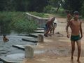
Wet locals

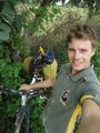
Felix at the hash
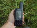
GPS Proof
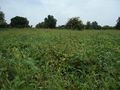
North view
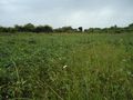
East view
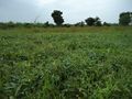
South view
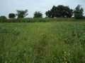
West view
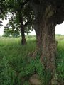
A nearby tree
My touring bike!
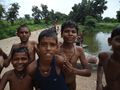
The locals again
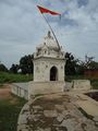
Goaty temple (look inside)

Cycle touring!


Felix Dance earned the Land geohash achievement
|
Felix Dance earned the Bicycle geohash achievement
|
Felix Dance earned the Graticule Unlocked Achievement
|